You are here: Home > Network List > TA - USArray Transportable Network (new EarthScope stations) Stations List
> Station I42A Draeger Farm, Ripon, WI, USA > Earthquake Result Viewer
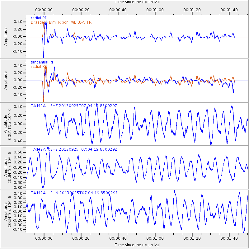
I42A Draeger Farm, Ripon, WI, USA - Earthquake Result Viewer
*The percent match for this event was below the threshold and hence no stack was calculated.
| Earthquake location: |
Southern East Pacific Rise |
| Earthquake latitude/longitude: |
-50.0/-113.7 |
| Earthquake time(UTC): |
2013/09/25 (268) 06:51:24 GMT |
| Earthquake Depth: |
10 km |
| Earthquake Magnitude: |
6.1 MWW, 6.0 MWC, 6.1 MWW, 6.1 MWC |
| Earthquake Catalog/Contributor: |
NEIC PDE/NEIC COMCAT |
|
| Network: |
TA USArray Transportable Network (new EarthScope stations) |
| Station: |
I42A Draeger Farm, Ripon, WI, USA |
| Lat/Lon: |
43.89 N/88.91 W |
| Elevation: |
298 m |
|
| Distance: |
95.9 deg |
| Az: |
17.773 deg |
| Baz: |
195.825 deg |
| Ray Param: |
$rayparam |
*The percent match for this event was below the threshold and hence was not used in the summary stack. |
|
| Radial Match: |
74.45563 % |
| Radial Bump: |
400 |
| Transverse Match: |
68.15036 % |
| Transverse Bump: |
400 |
| SOD ConfigId: |
626651 |
| Insert Time: |
2014-04-18 19:41:42.728 +0000 |
| GWidth: |
2.5 |
| Max Bumps: |
400 |
| Tol: |
0.001 |
|
Signal To Noise
| Channel | StoN | STA | LTA |
| TA:I42A: :BHZ:20130925T07:04:19.850029Z | 2.4513001 | 5.63688E-7 | 2.2995471E-7 |
| TA:I42A: :BHN:20130925T07:04:19.850029Z | 0.6494494 | 1.3841122E-7 | 2.1312087E-7 |
| TA:I42A: :BHE:20130925T07:04:19.850029Z | 1.4743952 | 2.557342E-7 | 1.7345025E-7 |
| Arrivals |
| Ps | |
| PpPs | |
| PsPs/PpSs | |


