You are here: Home > Network List > TA - USArray Transportable Network (new EarthScope stations) Stations List
> Station TPFO Pinon Flats, CA, USA > Earthquake Result Viewer
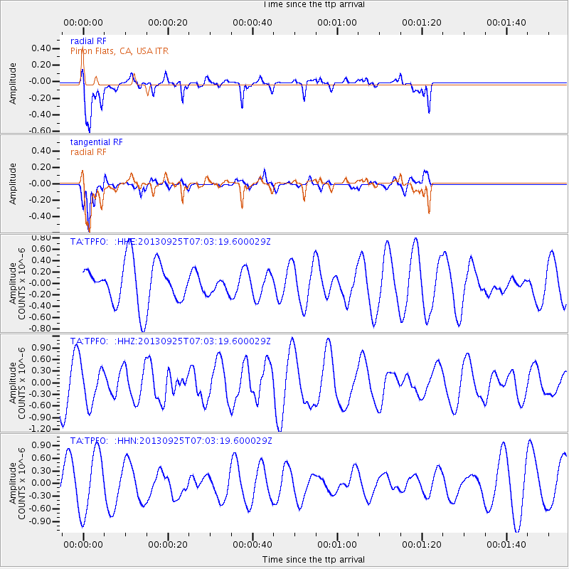
TPFO Pinon Flats, CA, USA - Earthquake Result Viewer
*The percent match for this event was below the threshold and hence no stack was calculated.
| Earthquake location: |
Southern East Pacific Rise |
| Earthquake latitude/longitude: |
-50.0/-113.7 |
| Earthquake time(UTC): |
2013/09/25 (268) 06:51:24 GMT |
| Earthquake Depth: |
10 km |
| Earthquake Magnitude: |
6.1 MWW, 6.0 MWC, 6.1 MWW, 6.1 MWC |
| Earthquake Catalog/Contributor: |
NEIC PDE/NEIC COMCAT |
|
| Network: |
TA USArray Transportable Network (new EarthScope stations) |
| Station: |
TPFO Pinon Flats, CA, USA |
| Lat/Lon: |
33.61 N/116.45 W |
| Elevation: |
1275 m |
|
| Distance: |
83.2 deg |
| Az: |
357.722 deg |
| Baz: |
178.237 deg |
| Ray Param: |
$rayparam |
*The percent match for this event was below the threshold and hence was not used in the summary stack. |
|
| Radial Match: |
49.36227 % |
| Radial Bump: |
400 |
| Transverse Match: |
63.453915 % |
| Transverse Bump: |
297 |
| SOD ConfigId: |
626651 |
| Insert Time: |
2014-04-18 19:44:30.812 +0000 |
| GWidth: |
2.5 |
| Max Bumps: |
400 |
| Tol: |
0.001 |
|
Signal To Noise
| Channel | StoN | STA | LTA |
| TA:TPFO: :HHZ:20130925T07:03:19.600029Z | 1.018112 | 4.9621696E-7 | 4.873894E-7 |
| TA:TPFO: :HHN:20130925T07:03:19.600029Z | 2.1575465 | 7.4930443E-7 | 3.4729467E-7 |
| TA:TPFO: :HHE:20130925T07:03:19.600029Z | 0.3740978 | 1.4128048E-7 | 3.7765656E-7 |
| Arrivals |
| Ps | |
| PpPs | |
| PsPs/PpSs | |


