You are here: Home > Network List > TA - USArray Transportable Network (new EarthScope stations) Stations List
> Station O51A Pataskala, OH, USA > Earthquake Result Viewer
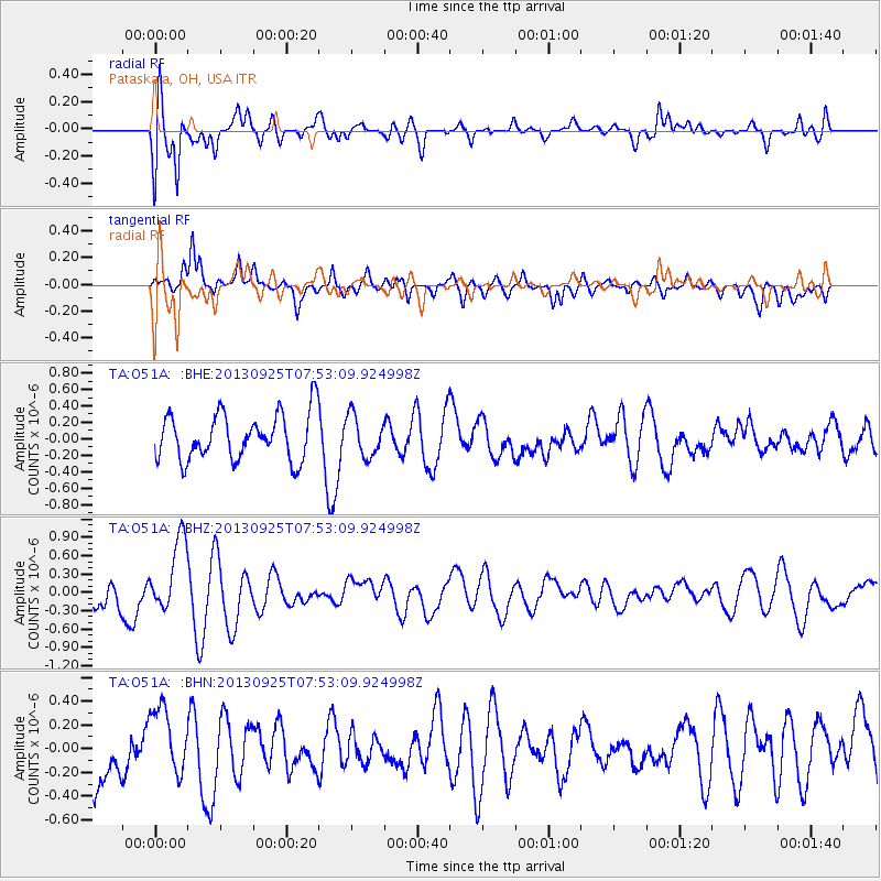
O51A Pataskala, OH, USA - Earthquake Result Viewer
*The percent match for this event was below the threshold and hence no stack was calculated.
| Earthquake location: |
Southern East Pacific Rise |
| Earthquake latitude/longitude: |
-50.0/-114.0 |
| Earthquake time(UTC): |
2013/09/25 (268) 07:40:23 GMT |
| Earthquake Depth: |
10 km |
| Earthquake Magnitude: |
5.5 MWC, 5.5 MWC |
| Earthquake Catalog/Contributor: |
NEIC PDE/NEIC COMCAT |
|
| Network: |
TA USArray Transportable Network (new EarthScope stations) |
| Station: |
O51A Pataskala, OH, USA |
| Lat/Lon: |
40.15 N/82.61 W |
| Elevation: |
380 m |
|
| Distance: |
93.9 deg |
| Az: |
23.585 deg |
| Baz: |
199.671 deg |
| Ray Param: |
$rayparam |
*The percent match for this event was below the threshold and hence was not used in the summary stack. |
|
| Radial Match: |
73.672035 % |
| Radial Bump: |
400 |
| Transverse Match: |
51.25075 % |
| Transverse Bump: |
400 |
| SOD ConfigId: |
626651 |
| Insert Time: |
2014-04-18 19:59:21.648 +0000 |
| GWidth: |
2.5 |
| Max Bumps: |
400 |
| Tol: |
0.001 |
|
Signal To Noise
| Channel | StoN | STA | LTA |
| TA:O51A: :BHZ:20130925T07:53:09.924998Z | 1.8622446 | 5.9640814E-7 | 3.2026307E-7 |
| TA:O51A: :BHN:20130925T07:53:09.924998Z | 1.2386906 | 2.9152213E-7 | 2.3534699E-7 |
| TA:O51A: :BHE:20130925T07:53:09.924998Z | 0.88482326 | 2.489153E-7 | 2.8131643E-7 |
| Arrivals |
| Ps | |
| PpPs | |
| PsPs/PpSs | |


