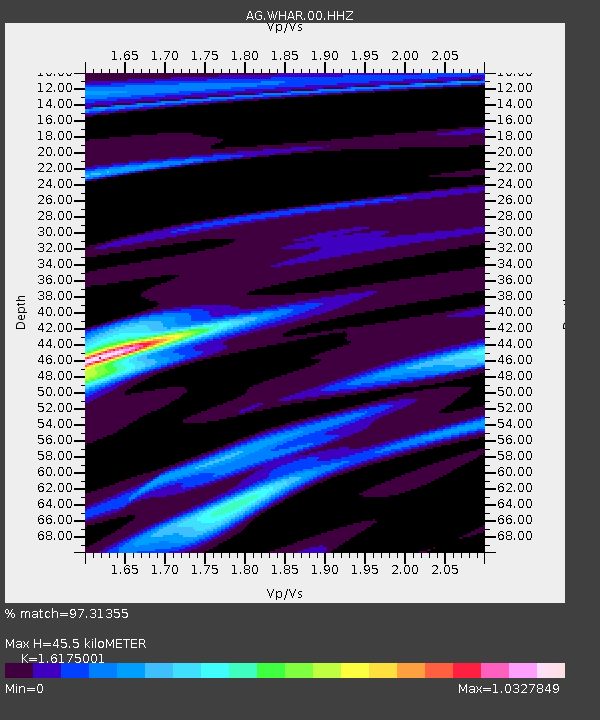
WHAR Woolly Hollow State Park,AR - Earthquake Result Viewer

Earthquake location: Near Coast Of Peru
Earthquake latitude/longitude: -15.8/-74.5
Earthquake time(UTC): 2013/09/25 (268) 16:42:43 GMT
Earthquake Depth: 40 km
Earthquake Magnitude: 7.1 MWW, 6.8 MI, 7.0 MWB, 7.0 MWC, 7.1 MWW, 7.1 MWC
Earthquake Catalog/Contributor: NEIC PDE/NEIC COMCAT
Network: AG Arkansas Seismic Network
Station: WHAR Woolly Hollow State Park,AR
Lat/Lon: 35.29 N/92.29 W
Elevation: 184 m
Distance: 53.6 deg
Az: 341.915 deg
Baz: 158.577 deg
Ray Param: 0.065922104
Estimated Moho Depth: 45.5 km
Estimated Crust Vp/Vs: 1.62
Assumed Crust Vp: 6.498 km/s
Estimated Crust Vs: 4.017 km/s
Estimated Crust Poisson's Ratio: 0.19
Radial Match: 97.31355 %
Radial Bump: 216
Transverse Match: 92.25363 %
Transverse Bump: 400
SOD ConfigId: 626651
Insert Time: 2014-04-18 20:05:44.710 +0000
GWidth: 2.5
Max Bumps: 400
Tol: 0.001

Signal To Noise

ChannelStoNSTALTA
AG:WHAR:00:HHZ:20130925T16:51:29.505022Z31.0810688.642628E-62.780673E-7
AG:WHAR:00:HHN:20130925T16:51:29.505022Z7.852.3581686E-63.0040366E-7
AG:WHAR:00:HHE:20130925T16:51:29.505022Z6.762281.1409697E-61.687256E-7
Arrivals
Ps4.6 SECOND
PpPs17 SECOND
PsPs/PpSs22 SECOND