You are here: Home > Network List > TA - USArray Transportable Network (new EarthScope stations) Stations List
> Station A36M Sachs Harbour, NT, CAN > Earthquake Result Viewer
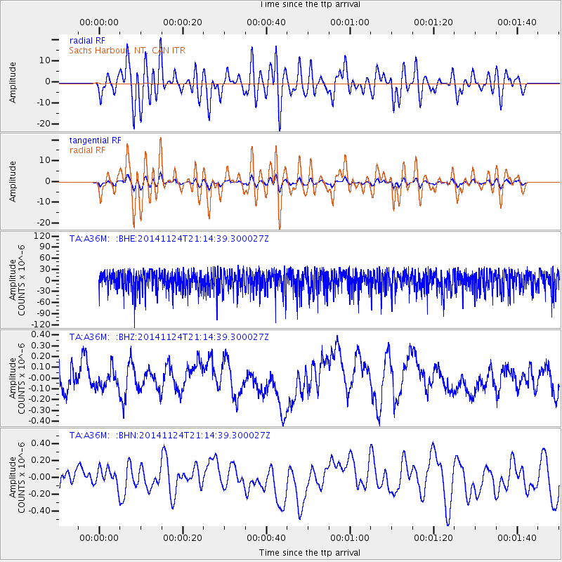
A36M Sachs Harbour, NT, CAN - Earthquake Result Viewer
*The percent match for this event was below the threshold and hence no stack was calculated.
| Earthquake location: |
Solomon Islands |
| Earthquake latitude/longitude: |
-6.0/155.0 |
| Earthquake time(UTC): |
2014/11/24 (328) 21:02:19 GMT |
| Earthquake Depth: |
170 km |
| Earthquake Magnitude: |
5.6 MWW, 5.6 MWB, 5.7 MWC |
| Earthquake Catalog/Contributor: |
NEIC PDE/NEIC COMCAT |
|
| Network: |
TA USArray Transportable Network (new EarthScope stations) |
| Station: |
A36M Sachs Harbour, NT, CAN |
| Lat/Lon: |
71.99 N/125.25 W |
| Elevation: |
32 m |
|
| Distance: |
92.5 deg |
| Az: |
17.847 deg |
| Baz: |
258.473 deg |
| Ray Param: |
$rayparam |
*The percent match for this event was below the threshold and hence was not used in the summary stack. |
|
| Radial Match: |
51.188374 % |
| Radial Bump: |
400 |
| Transverse Match: |
51.536537 % |
| Transverse Bump: |
400 |
| SOD ConfigId: |
3390531 |
| Insert Time: |
2019-04-15 04:42:48.191 +0000 |
| GWidth: |
2.5 |
| Max Bumps: |
400 |
| Tol: |
0.001 |
|
Signal To Noise
| Channel | StoN | STA | LTA |
| TA:A36M: :BHZ:20141124T21:14:39.300027Z | 0.49967983 | 9.169984E-8 | 1.835172E-7 |
| TA:A36M: :BHN:20141124T21:14:39.300027Z | 0.6384858 | 1.3251896E-7 | 2.0755193E-7 |
| TA:A36M: :BHE:20141124T21:14:39.300027Z | 1.0049661 | 2.5164418E-5 | 2.5040064E-5 |
| Arrivals |
| Ps | |
| PpPs | |
| PsPs/PpSs | |


