You are here: Home > Network List > BK - Berkeley Digital Seismograph Network Stations List
> Station MCCM Marconi Conference Center, Marshall, CA, USA > Earthquake Result Viewer
MCCM Marconi Conference Center, Marshall, CA, USA - Earthquake Result Viewer
| Earthquake location: |
Near Coast Of Peru |
| Earthquake latitude/longitude: |
-15.8/-74.5 |
| Earthquake time(UTC): |
2013/09/25 (268) 16:42:43 GMT |
| Earthquake Depth: |
40 km |
| Earthquake Magnitude: |
7.1 MWW, 6.8 MI, 7.0 MWB, 7.0 MWC, 7.1 MWW, 7.1 MWC |
| Earthquake Catalog/Contributor: |
NEIC PDE/NEIC COMCAT |
|
| Network: |
BK Berkeley Digital Seismograph Network |
| Station: |
MCCM Marconi Conference Center, Marshall, CA, USA |
| Lat/Lon: |
38.14 N/122.88 W |
| Elevation: |
-7.7 m |
|
| Distance: |
70.3 deg |
| Az: |
321.243 deg |
| Baz: |
130.163 deg |
| Ray Param: |
0.05501442 |
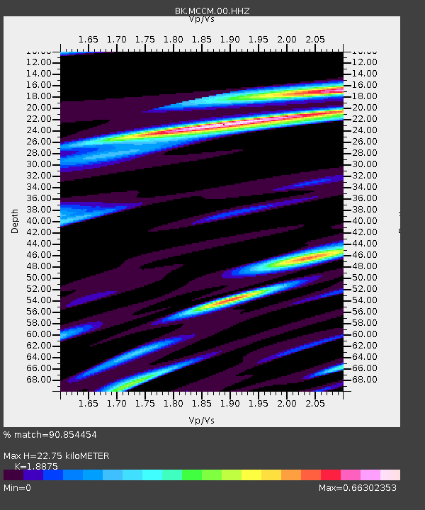
| Estimated Moho Depth: |
22.75 km |
| Estimated Crust Vp/Vs: |
1.89 |
| Assumed Crust Vp: |
6.472 km/s |
| Estimated Crust Vs: |
3.429 km/s |
| Estimated Crust Poisson's Ratio: |
0.30 |
|
| Radial Match: |
90.854454 % |
| Radial Bump: |
325 |
| Transverse Match: |
83.7583 % |
| Transverse Bump: |
400 |
| SOD ConfigId: |
626651 |
| Insert Time: |
2014-04-18 20:10:19.773 +0000 |
| GWidth: |
2.5 |
| Max Bumps: |
400 |
| Tol: |
0.001 |
|

Signal To Noise
| Channel | StoN | STA | LTA |
| BK:MCCM:00:HHZ:20130925T16:53:21.527971Z | 5.2920017 | 2.738032E-6 | 5.173906E-7 |
| BK:MCCM:00:HHN:20130925T16:53:21.527971Z | 0.9732684 | 1.1691614E-6 | 1.2012732E-6 |
| BK:MCCM:00:HHE:20130925T16:53:21.527971Z | 1.6470493 | 1.3324391E-6 | 8.0898553E-7 |
| Arrivals |
| Ps | 3.2 SECOND |
| PpPs | 9.8 SECOND |
| PsPs/PpSs | 13 SECOND |


