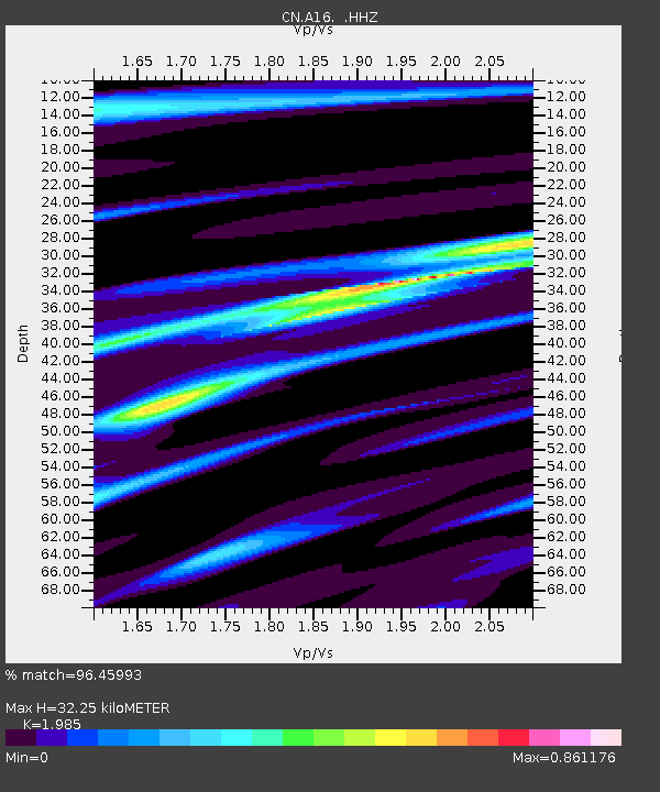
A16 RIVIERE OUELLE, QC - Earthquake Result Viewer

Earthquake location: Near Coast Of Peru
Earthquake latitude/longitude: -15.8/-74.5
Earthquake time(UTC): 2013/09/25 (268) 16:42:43 GMT
Earthquake Depth: 40 km
Earthquake Magnitude: 7.1 MWW, 6.8 MI, 7.0 MWB, 7.0 MWC, 7.1 MWW, 7.1 MWC
Earthquake Catalog/Contributor: NEIC PDE/NEIC COMCAT
Network: CN Canadian National Seismograph Network
Station: A16 RIVIERE OUELLE, QC
Lat/Lon: 47.47 N/70.01 W
Elevation: 15 m
Distance: 63.1 deg
Az: 3.424 deg
Baz: 184.861 deg
Ray Param: 0.059691083
Estimated Moho Depth: 32.25 km
Estimated Crust Vp/Vs: 1.99
Assumed Crust Vp: 6.61 km/s
Estimated Crust Vs: 3.33 km/s
Estimated Crust Poisson's Ratio: 0.33
Radial Match: 96.45993 %
Radial Bump: 270
Transverse Match: 81.18806 %
Transverse Bump: 400
SOD ConfigId: 626651
Insert Time: 2014-04-18 20:12:57.713 +0000
GWidth: 2.5
Max Bumps: 400
Tol: 0.001

Signal To Noise

ChannelStoNSTALTA
CN:A16: :HHZ:20130925T16:52:36.14998Z7.35066652.4637186E-63.351694E-7
CN:A16: :HHN:20130925T16:52:36.14998Z0.97806446.702931E-76.8532614E-7
CN:A16: :HHE:20130925T16:52:36.14998Z0.497024062.0338503E-74.0920563E-7
Arrivals
Ps5.0 SECOND
PpPs14 SECOND
PsPs/PpSs19 SECOND