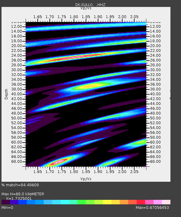
KULLO Kullorsuaq, Greenland - Earthquake Result Viewer

Earthquake location: Near Coast Of Peru
Earthquake latitude/longitude: -15.8/-74.5
Earthquake time(UTC): 2013/09/25 (268) 16:42:43 GMT
Earthquake Depth: 40 km
Earthquake Magnitude: 7.1 MWW, 6.8 MI, 7.0 MWB, 7.0 MWC, 7.1 MWW, 7.1 MWC
Earthquake Catalog/Contributor: NEIC PDE/NEIC COMCAT
Network: DK Danish Seismological Network
Station: KULLO Kullorsuaq, Greenland
Lat/Lon: 74.58 N/57.22 W
Elevation: 44 m
Distance: 90.9 deg
Az: 4.562 deg
Baz: 196.626 deg
Ray Param: 0.041635923
Estimated Moho Depth: 68.0 km
Estimated Crust Vp/Vs: 1.73
Assumed Crust Vp: 6.424 km/s
Estimated Crust Vs: 3.708 km/s
Estimated Crust Poisson's Ratio: 0.25
Radial Match: 84.48608 %
Radial Bump: 400
Transverse Match: 84.10102 %
Transverse Bump: 400
SOD ConfigId: 626651
Insert Time: 2014-04-18 20:15:03.644 +0000
GWidth: 2.5
Max Bumps: 400
Tol: 0.001

Signal To Noise

ChannelStoNSTALTA
DK:KULLO: :HHZ:20130925T16:55:11.310015Z8.0746711.741341E-62.1565472E-7
DK:KULLO: :HHN:20130925T16:55:11.310015Z3.03736936.7388083E-72.2186332E-7
DK:KULLO: :HHE:20130925T16:55:11.310015Z1.1349132.740893E-72.415069E-7
Arrivals
Ps7.9 SECOND
PpPs28 SECOND
PsPs/PpSs36 SECOND