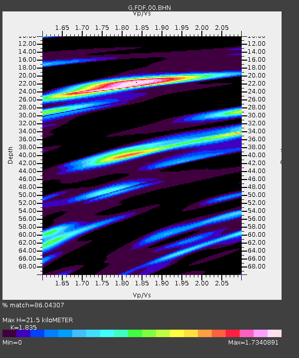
FDF Fort de France, Martinique France - Earthquake Result Viewer
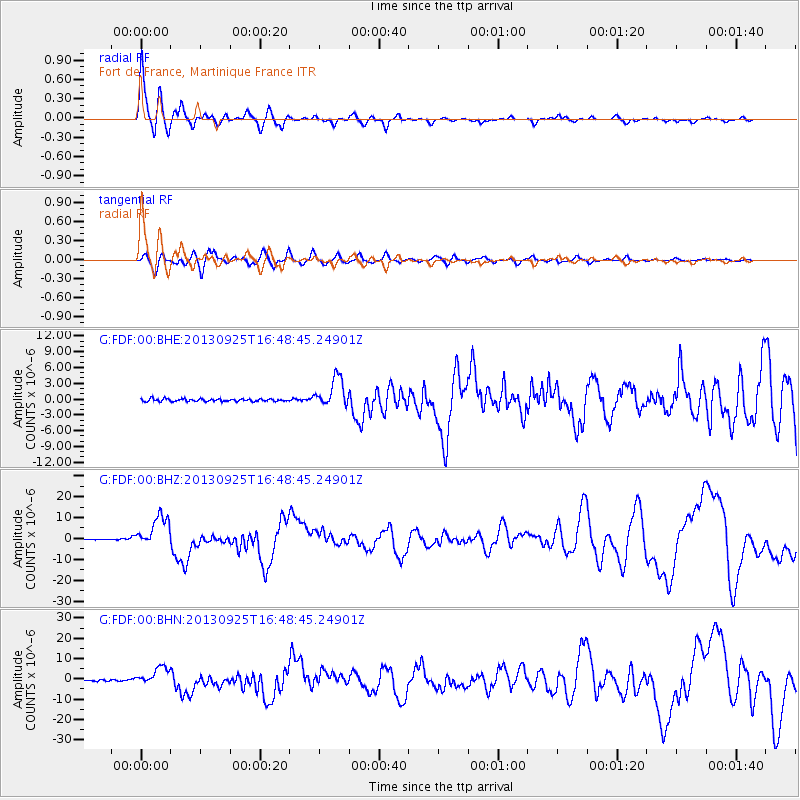
Earthquake location: Near Coast Of Peru
Earthquake latitude/longitude: -15.8/-74.5
Earthquake time(UTC): 2013/09/25 (268) 16:42:43 GMT
Earthquake Depth: 40 km
Earthquake Magnitude: 7.1 MWW, 6.8 MI, 7.0 MWB, 7.0 MWC, 7.1 MWW, 7.1 MWC
Earthquake Catalog/Contributor: NEIC PDE/NEIC COMCAT
Network: G GEOSCOPE
Station: FDF Fort de France, Martinique France
Lat/Lon: 14.73 N/61.14 W
Elevation: 467 m
Distance: 33.1 deg
Az: 24.164 deg
Baz: 204.031 deg
Ray Param: 0.07827592
Estimated Moho Depth: 21.5 km
Estimated Crust Vp/Vs: 1.84
Assumed Crust Vp: 5.88 km/s
Estimated Crust Vs: 3.205 km/s
Estimated Crust Poisson's Ratio: 0.29
Radial Match: 86.04307 %
Radial Bump: 400
Transverse Match: 74.860695 %
Transverse Bump: 400
SOD ConfigId: 626651
Insert Time: 2014-04-18 20:15:51.146 +0000
GWidth: 2.5
Max Bumps: 400
Tol: 0.001

Signal To Noise

ChannelStoNSTALTA
G:FDF:00:BHZ:20130925T16:48:45.24901Z44.0779887.49079E-61.69944E-7
G:FDF:00:BHN:20130925T16:48:45.24901Z17.0221944.464916E-62.6229966E-7
G:FDF:00:BHE:20130925T16:48:45.24901Z11.657692.7851509E-62.3891104E-7
Arrivals
Ps3.2 SECOND
PpPs9.7 SECOND
PsPs/PpSs13 SECOND