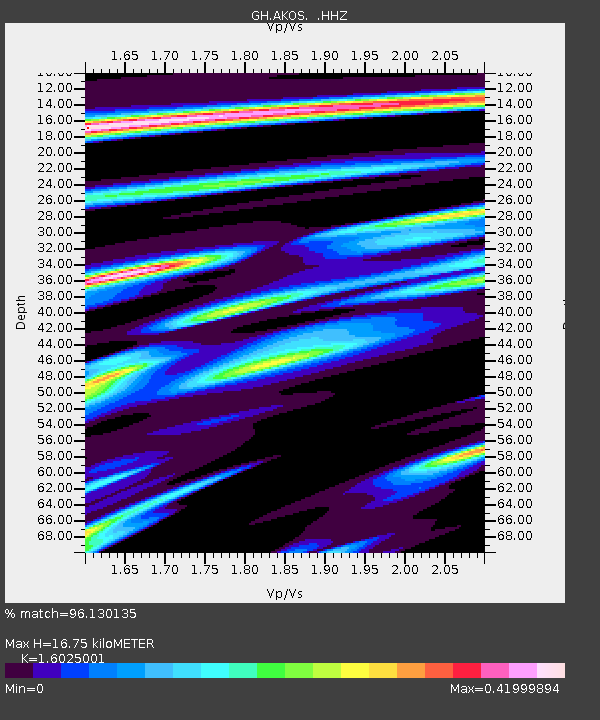
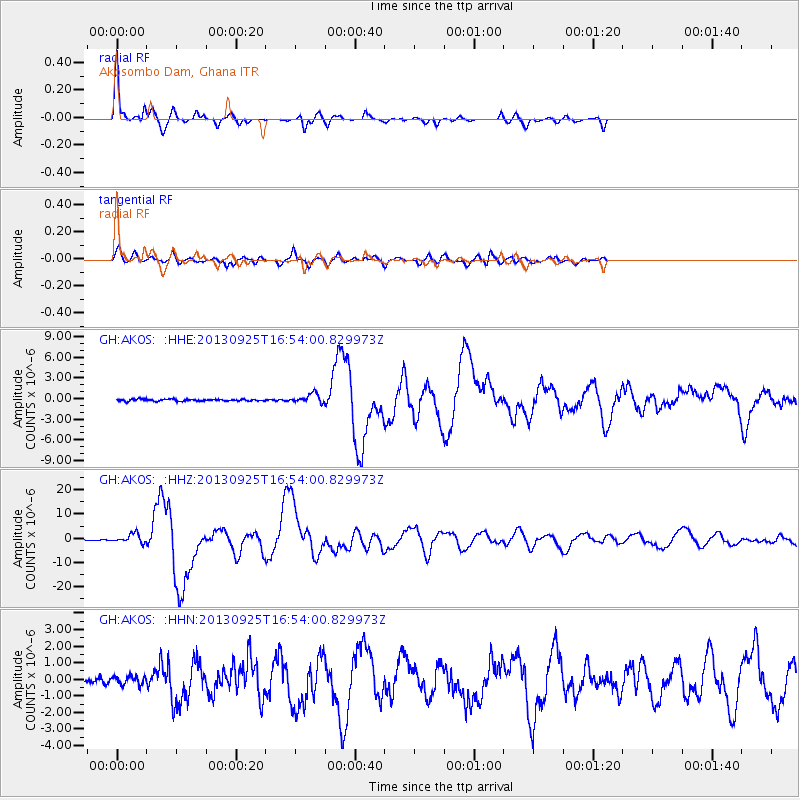
AKOS Akosombo Dam, Ghana - Earthquake Result Viewer

Earthquake location: Near Coast Of Peru
Earthquake latitude/longitude: -15.8/-74.5
Earthquake time(UTC): 2013/09/25 (268) 16:42:43 GMT
Earthquake Depth: 40 km
Earthquake Magnitude: 7.1 MWW, 6.8 MI, 7.0 MWB, 7.0 MWC, 7.1 MWW, 7.1 MWC
Earthquake Catalog/Contributor: NEIC PDE/NEIC COMCAT
Network: GH Ghana Digital Seismic Network
Station: AKOS Akosombo Dam, Ghana
Lat/Lon: 6.30 N/0.07 E
Elevation: 217 m
Distance: 77.0 deg
Az: 79.559 deg
Baz: 252.222 deg
Ray Param: 0.050549664
Estimated Moho Depth: 16.75 km
Estimated Crust Vp/Vs: 1.60
Assumed Crust Vp: 6.612 km/s
Estimated Crust Vs: 4.126 km/s
Estimated Crust Poisson's Ratio: 0.18
Radial Match: 96.130135 %
Radial Bump: 278
Transverse Match: 90.81707 %
Transverse Bump: 400
SOD ConfigId: 626651
Insert Time: 2014-04-18 20:16:53.146 +0000
GWidth: 2.5
Max Bumps: 400
Tol: 0.001

Signal To Noise

ChannelStoNSTALTA
GH:AKOS: :HHZ:20130925T16:54:00.829973Z10.3817751.9054849E-61.8354133E-7
GH:AKOS: :HHN:20130925T16:54:00.829973Z1.30759642.618901E-72.0028361E-7
GH:AKOS: :HHE:20130925T16:54:00.829973Z4.81757456.7604645E-71.4032922E-7
Arrivals
Ps1.6 SECOND
PpPs6.4 SECOND
PsPs/PpSs7.9 SECOND