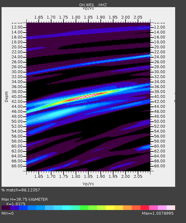
WEIJ Weija Dam, Ghana - Earthquake Result Viewer

Earthquake location: Near Coast Of Peru
Earthquake latitude/longitude: -15.8/-74.5
Earthquake time(UTC): 2013/09/25 (268) 16:42:43 GMT
Earthquake Depth: 40 km
Earthquake Magnitude: 7.1 MWW, 6.8 MI, 7.0 MWB, 7.0 MWC, 7.1 MWW, 7.1 MWC
Earthquake Catalog/Contributor: NEIC PDE/NEIC COMCAT
Network: GH Ghana Digital Seismic Network
Station: WEIJ Weija Dam, Ghana
Lat/Lon: 5.59 N/0.33 W
Elevation: 203 m
Distance: 76.4 deg
Az: 80.124 deg
Baz: 252.311 deg
Ray Param: 0.050947998
Estimated Moho Depth: 39.75 km
Estimated Crust Vp/Vs: 1.84
Assumed Crust Vp: 6.472 km/s
Estimated Crust Vs: 3.522 km/s
Estimated Crust Poisson's Ratio: 0.29
Radial Match: 96.12357 %
Radial Bump: 311
Transverse Match: 85.54558 %
Transverse Bump: 400
SOD ConfigId: 626651
Insert Time: 2014-04-18 20:17:03.795 +0000
GWidth: 2.5
Max Bumps: 400
Tol: 0.001

Signal To Noise

ChannelStoNSTALTA
GH:WEIJ: :HHZ:20130925T16:53:57.500017Z8.5134761.7958637E-62.1094364E-7
GH:WEIJ: :HHN:20130925T16:53:57.500017Z1.41736282.931902E-72.0685614E-7
GH:WEIJ: :HHE:20130925T16:53:57.500017Z3.28623996.611167E-72.0117724E-7
Arrivals
Ps5.3 SECOND
PpPs17 SECOND
PsPs/PpSs22 SECOND