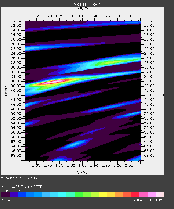
JTMT Jette Lake, Montana - Earthquake Result Viewer

Earthquake location: Near Coast Of Peru
Earthquake latitude/longitude: -15.8/-74.5
Earthquake time(UTC): 2013/09/25 (268) 16:42:43 GMT
Earthquake Depth: 40 km
Earthquake Magnitude: 7.1 MWW, 6.8 MI, 7.0 MWB, 7.0 MWC, 7.1 MWW, 7.1 MWC
Earthquake Catalog/Contributor: NEIC PDE/NEIC COMCAT
Network: MB Montana Regional Seismic Network
Station: JTMT Jette Lake, Montana
Lat/Lon: 47.75 N/114.28 W
Elevation: 1469 m
Distance: 72.6 deg
Az: 333.099 deg
Baz: 139.813 deg
Ray Param: 0.053490326
Estimated Moho Depth: 36.0 km
Estimated Crust Vp/Vs: 1.73
Assumed Crust Vp: 6.622 km/s
Estimated Crust Vs: 3.839 km/s
Estimated Crust Poisson's Ratio: 0.25
Radial Match: 96.344475 %
Radial Bump: 339
Transverse Match: 88.9658 %
Transverse Bump: 400
SOD ConfigId: 626651
Insert Time: 2014-04-18 20:21:40.570 +0000
GWidth: 2.5
Max Bumps: 400
Tol: 0.001

Signal To Noise

ChannelStoNSTALTA
MB:JTMT: :BHZ:20130925T16:53:35.404985Z11.3757941.961546E-61.7243157E-7
MB:JTMT: :BHN:20130925T16:53:35.404985Z4.1840987.2981584E-71.7442609E-7
MB:JTMT: :BHE:20130925T16:53:35.404985Z3.47100077.216216E-72.0790016E-7
Arrivals
Ps4.1 SECOND
PpPs14 SECOND
PsPs/PpSs18 SECOND