You are here: Home > Network List > CI - Caltech Regional Seismic Network Stations List
> Station TIN Tinemaha, Big Pine, CA, USA > Earthquake Result Viewer
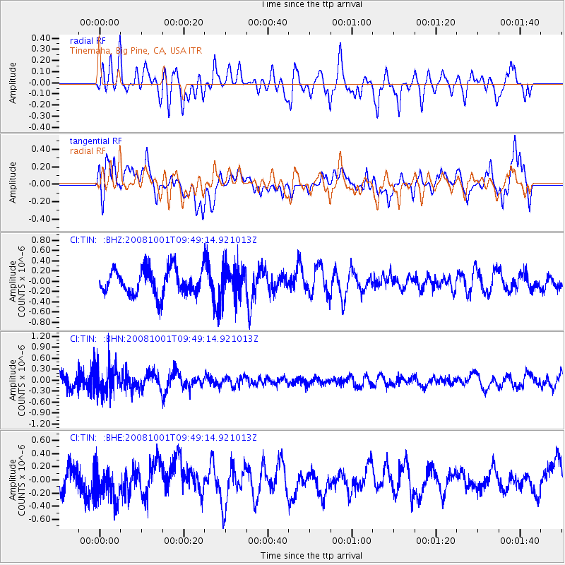
TIN Tinemaha, Big Pine, CA, USA - Earthquake Result Viewer
*The percent match for this event was below the threshold and hence no stack was calculated.
| Earthquake location: |
Southeast Of Honshu, Japan |
| Earthquake latitude/longitude: |
30.2/138.8 |
| Earthquake time(UTC): |
2008/10/01 (275) 09:38:12 GMT |
| Earthquake Depth: |
414 km |
| Earthquake Magnitude: |
5.7 MW, 5.1 MB, 5.7 MW |
| Earthquake Catalog/Contributor: |
WHDF/NEIC |
|
| Network: |
CI Caltech Regional Seismic Network |
| Station: |
TIN Tinemaha, Big Pine, CA, USA |
| Lat/Lon: |
37.05 N/118.23 W |
| Elevation: |
1197 m |
|
| Distance: |
81.7 deg |
| Az: |
51.978 deg |
| Baz: |
301.483 deg |
| Ray Param: |
$rayparam |
*The percent match for this event was below the threshold and hence was not used in the summary stack. |
|
| Radial Match: |
41.124847 % |
| Radial Bump: |
400 |
| Transverse Match: |
59.523098 % |
| Transverse Bump: |
400 |
| SOD ConfigId: |
2556 |
| Insert Time: |
2010-02-25 20:52:21.917 +0000 |
| GWidth: |
2.5 |
| Max Bumps: |
400 |
| Tol: |
0.001 |
|
Signal To Noise
| Channel | StoN | STA | LTA |
| CI:TIN: :BHN:20081001T09:49:14.921013Z | 2.8446 | 3.8366628E-7 | 1.348753E-7 |
| CI:TIN: :BHE:20081001T09:49:14.921013Z | 1.2586892 | 2.615685E-7 | 2.0781025E-7 |
| CI:TIN: :BHZ:20081001T09:49:14.921013Z | 1.2464372 | 3.0514002E-7 | 2.4480977E-7 |
| Arrivals |
| Ps | |
| PpPs | |
| PsPs/PpSs | |


