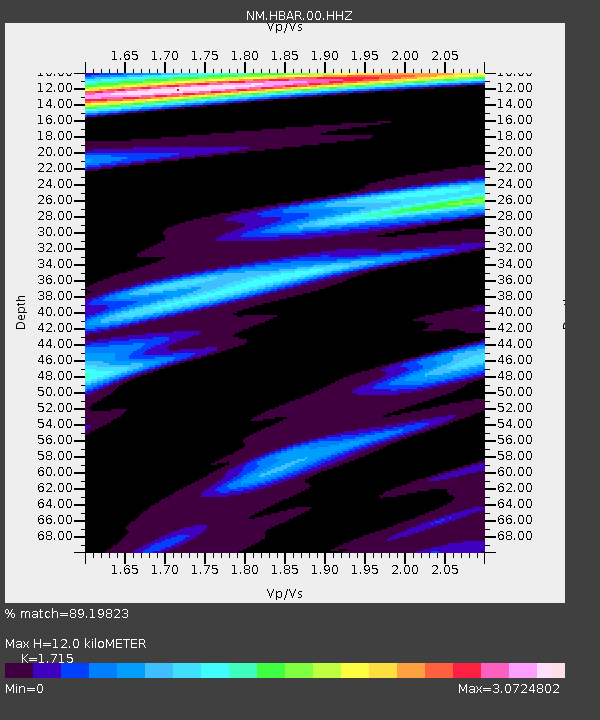
HBAR Harrisburg,AR(CERI) - Earthquake Result Viewer

Earthquake location: Near Coast Of Peru
Earthquake latitude/longitude: -15.8/-74.5
Earthquake time(UTC): 2013/09/25 (268) 16:42:43 GMT
Earthquake Depth: 40 km
Earthquake Magnitude: 7.1 MWW, 6.8 MI, 7.0 MWB, 7.0 MWC, 7.1 MWW, 7.1 MWC
Earthquake Catalog/Contributor: NEIC PDE/NEIC COMCAT
Network: NM Cooperative New Madrid Seismic Network
Station: HBAR Harrisburg,AR(CERI)
Lat/Lon: 35.56 N/90.66 W
Elevation: 74 m
Distance: 53.4 deg
Az: 343.584 deg
Baz: 160.513 deg
Ray Param: 0.066068105
Estimated Moho Depth: 12.0 km
Estimated Crust Vp/Vs: 1.72
Assumed Crust Vp: 6.273 km/s
Estimated Crust Vs: 3.658 km/s
Estimated Crust Poisson's Ratio: 0.24
Radial Match: 89.19823 %
Radial Bump: 400
Transverse Match: 80.78777 %
Transverse Bump: 400
SOD ConfigId: 626651
Insert Time: 2014-04-18 20:23:03.388 +0000
GWidth: 2.5
Max Bumps: 400
Tol: 0.001

Signal To Noise

ChannelStoNSTALTA
NM:HBAR:00:HHZ:20130925T16:51:27.914995Z34.6076479.992794E-62.8874524E-7
NM:HBAR:00:HHN:20130925T16:51:27.914995Z5.2840422.5780678E-64.8789695E-7
NM:HBAR:00:HHE:20130925T16:51:27.914995Z2.41833621.349042E-65.578389E-7
Arrivals
Ps1.4 SECOND
PpPs4.9 SECOND
PsPs/PpSs6.4 SECOND