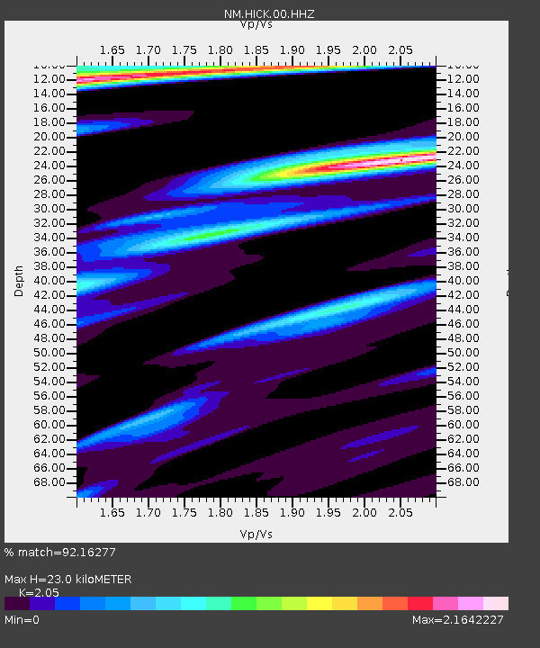
HICK Hickman,KY - Earthquake Result Viewer

Earthquake location: Near Coast Of Peru
Earthquake latitude/longitude: -15.8/-74.5
Earthquake time(UTC): 2013/09/25 (268) 16:42:43 GMT
Earthquake Depth: 40 km
Earthquake Magnitude: 7.1 MWW, 6.8 MI, 7.0 MWB, 7.0 MWC, 7.1 MWW, 7.1 MWC
Earthquake Catalog/Contributor: NEIC PDE/NEIC COMCAT
Network: NM Cooperative New Madrid Seismic Network
Station: HICK Hickman,KY
Lat/Lon: 36.54 N/89.23 W
Elevation: 141 m
Distance: 53.9 deg
Az: 345.335 deg
Baz: 162.388 deg
Ray Param: 0.06569061
Estimated Moho Depth: 23.0 km
Estimated Crust Vp/Vs: 2.05
Assumed Crust Vp: 6.444 km/s
Estimated Crust Vs: 3.143 km/s
Estimated Crust Poisson's Ratio: 0.34
Radial Match: 92.16277 %
Radial Bump: 400
Transverse Match: 78.99202 %
Transverse Bump: 400
SOD ConfigId: 626651
Insert Time: 2014-04-18 20:23:09.752 +0000
GWidth: 2.5
Max Bumps: 400
Tol: 0.001

Signal To Noise

ChannelStoNSTALTA
NM:HICK:00:HHZ:20130925T16:51:32.03499Z50.0889321.2224975E-52.4406538E-7
NM:HICK:00:HHN:20130925T16:51:32.03499Z12.3738486.53779E-65.2835543E-7
NM:HICK:00:HHE:20130925T16:51:32.03499Z5.0352963.2442242E-66.442966E-7
Arrivals
Ps3.9 SECOND
PpPs10 SECOND
PsPs/PpSs14 SECOND