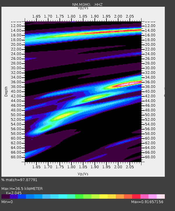
MGMO Mountain Grove, MO - Earthquake Result Viewer

Earthquake location: Near Coast Of Peru
Earthquake latitude/longitude: -15.8/-74.5
Earthquake time(UTC): 2013/09/25 (268) 16:42:43 GMT
Earthquake Depth: 40 km
Earthquake Magnitude: 7.1 MWW, 6.8 MI, 7.0 MWB, 7.0 MWC, 7.1 MWW, 7.1 MWC
Earthquake Catalog/Contributor: NEIC PDE/NEIC COMCAT
Network: NM Cooperative New Madrid Seismic Network
Station: MGMO Mountain Grove, MO
Lat/Lon: 37.15 N/92.27 W
Elevation: 453 m
Distance: 55.3 deg
Az: 342.759 deg
Baz: 159.081 deg
Ray Param: 0.06479887
Estimated Moho Depth: 36.5 km
Estimated Crust Vp/Vs: 2.05
Assumed Crust Vp: 6.53 km/s
Estimated Crust Vs: 3.193 km/s
Estimated Crust Poisson's Ratio: 0.34
Radial Match: 97.87791 %
Radial Bump: 179
Transverse Match: 90.4717 %
Transverse Bump: 372
SOD ConfigId: 626651
Insert Time: 2014-04-18 20:23:17.938 +0000
GWidth: 2.5
Max Bumps: 400
Tol: 0.001

Signal To Noise

ChannelStoNSTALTA
NM:MGMO: :HHZ:20130925T16:51:42.027971Z69.231878.770738E-61.2668642E-7
NM:MGMO: :HHN:20130925T16:51:42.027971Z18.762214.2264496E-62.2526395E-7
NM:MGMO: :HHE:20130925T16:51:42.027971Z8.2600991.2138635E-61.4695507E-7
Arrivals
Ps6.1 SECOND
PpPs16 SECOND
PsPs/PpSs22 SECOND