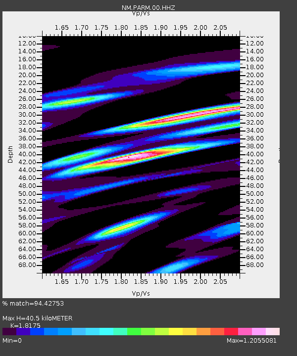
PARM Stahl Farm,MO - Earthquake Result Viewer

Earthquake location: Near Coast Of Peru
Earthquake latitude/longitude: -15.8/-74.5
Earthquake time(UTC): 2013/09/25 (268) 16:42:43 GMT
Earthquake Depth: 40 km
Earthquake Magnitude: 7.1 MWW, 6.8 MI, 7.0 MWB, 7.0 MWC, 7.1 MWW, 7.1 MWC
Earthquake Catalog/Contributor: NEIC PDE/NEIC COMCAT
Network: NM Cooperative New Madrid Seismic Network
Station: PARM Stahl Farm,MO
Lat/Lon: 36.66 N/89.75 W
Elevation: 85 m
Distance: 54.2 deg
Az: 344.887 deg
Baz: 161.814 deg
Ray Param: 0.06553716
Estimated Moho Depth: 40.5 km
Estimated Crust Vp/Vs: 1.82
Assumed Crust Vp: 6.444 km/s
Estimated Crust Vs: 3.545 km/s
Estimated Crust Poisson's Ratio: 0.28
Radial Match: 94.42753 %
Radial Bump: 400
Transverse Match: 74.92341 %
Transverse Bump: 400
SOD ConfigId: 626651
Insert Time: 2014-04-18 20:23:29.649 +0000
GWidth: 2.5
Max Bumps: 400
Tol: 0.001

Signal To Noise

ChannelStoNSTALTA
NM:PARM:00:HHZ:20130925T16:51:33.825029Z31.1885411.2149986E-53.895657E-7
NM:PARM:00:HHN:20130925T16:51:33.825029Z14.8594056.7809824E-64.563428E-7
NM:PARM:00:HHE:20130925T16:51:33.825029Z5.9119182.3453126E-63.9670928E-7
Arrivals
Ps5.4 SECOND
PpPs17 SECOND
PsPs/PpSs22 SECOND