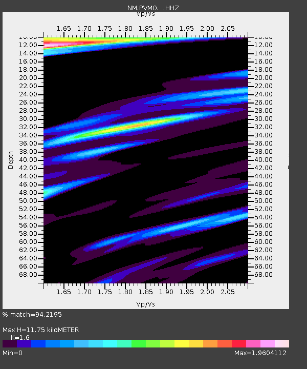
PVMO UM Delta Research Portageville, MO - Earthquake Result Viewer

Earthquake location: Near Coast Of Peru
Earthquake latitude/longitude: -15.8/-74.5
Earthquake time(UTC): 2013/09/25 (268) 16:42:43 GMT
Earthquake Depth: 40 km
Earthquake Magnitude: 7.1 MWW, 6.8 MI, 7.0 MWB, 7.0 MWC, 7.1 MWW, 7.1 MWC
Earthquake Catalog/Contributor: NEIC PDE/NEIC COMCAT
Network: NM Cooperative New Madrid Seismic Network
Station: PVMO UM Delta Research Portageville, MO
Lat/Lon: 36.41 N/89.70 W
Elevation: 98 m
Distance: 53.9 deg
Az: 344.84 deg
Baz: 161.818 deg
Ray Param: 0.0656933
Estimated Moho Depth: 11.75 km
Estimated Crust Vp/Vs: 1.60
Assumed Crust Vp: 6.444 km/s
Estimated Crust Vs: 4.027 km/s
Estimated Crust Poisson's Ratio: 0.18
Radial Match: 94.2195 %
Radial Bump: 400
Transverse Match: 81.58684 %
Transverse Bump: 400
SOD ConfigId: 626651
Insert Time: 2014-04-18 20:23:42.699 +0000
GWidth: 2.5
Max Bumps: 400
Tol: 0.001

Signal To Noise

ChannelStoNSTALTA
NM:PVMO: :HHZ:20130925T16:51:32.000017Z15.1094561.1245997E-57.443019E-7
NM:PVMO: :HHN:20130925T16:51:32.000017Z7.1576167.131882E-69.964047E-7
NM:PVMO: :HHE:20130925T16:51:32.000017Z2.96069262.5599052E-68.646305E-7
Arrivals
Ps1.2 SECOND
PpPs4.5 SECOND
PsPs/PpSs5.6 SECOND