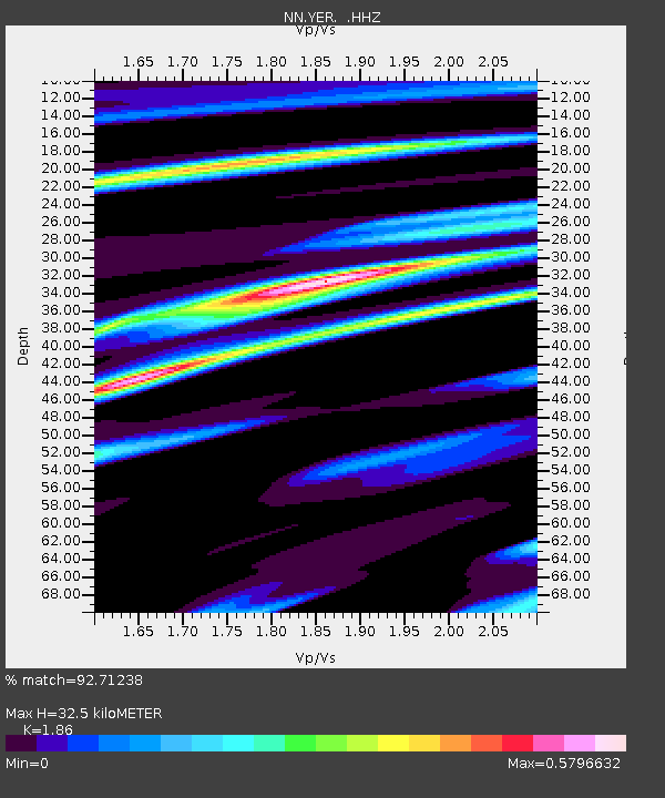
YER Yerington, Nevada w84gm - Earthquake Result Viewer

Earthquake location: Near Coast Of Peru
Earthquake latitude/longitude: -15.8/-74.5
Earthquake time(UTC): 2013/09/25 (268) 16:42:43 GMT
Earthquake Depth: 40 km
Earthquake Magnitude: 7.1 MWW, 6.8 MI, 7.0 MWB, 7.0 MWC, 7.1 MWW, 7.1 MWC
Earthquake Catalog/Contributor: NEIC PDE/NEIC COMCAT
Network: NN Western Great Basin/Eastern Sierra Nevada
Station: YER Yerington, Nevada w84gm
Lat/Lon: 38.99 N/119.24 W
Elevation: 1857 m
Distance: 68.7 deg
Az: 323.94 deg
Baz: 133.368 deg
Ray Param: 0.056051753
Estimated Moho Depth: 32.5 km
Estimated Crust Vp/Vs: 1.86
Assumed Crust Vp: 6.279 km/s
Estimated Crust Vs: 3.376 km/s
Estimated Crust Poisson's Ratio: 0.30
Radial Match: 92.71238 %
Radial Bump: 337
Transverse Match: 87.72445 %
Transverse Bump: 400
SOD ConfigId: 626651
Insert Time: 2014-04-18 20:24:34.349 +0000
GWidth: 2.5
Max Bumps: 400
Tol: 0.001

Signal To Noise

ChannelStoNSTALTA
NN:YER: :HHZ:20130925T16:53:11.865007Z4.83377552.1825688E-64.5152467E-7
NN:YER: :HHN:20130925T16:53:11.865007Z2.79049567.4744986E-72.678556E-7
NN:YER: :HHE:20130925T16:53:11.865007Z1.90310357.300898E-73.8363117E-7
Arrivals
Ps4.6 SECOND
PpPs14 SECOND
PsPs/PpSs19 SECOND