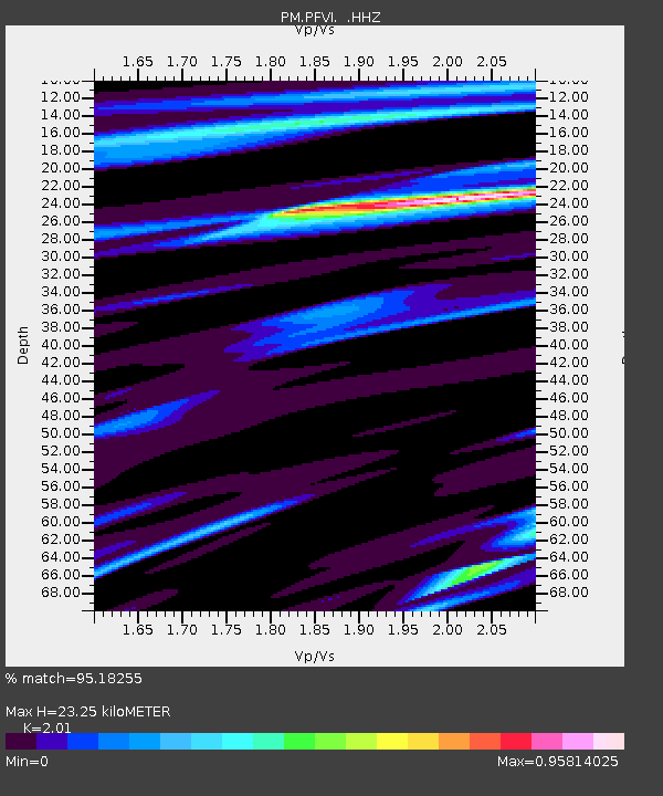
PFVI PM.PFVI - Earthquake Result Viewer

Earthquake location: Near Coast Of Peru
Earthquake latitude/longitude: -15.8/-74.5
Earthquake time(UTC): 2013/09/25 (268) 16:42:43 GMT
Earthquake Depth: 40 km
Earthquake Magnitude: 7.1 MWW, 6.8 MI, 7.0 MWB, 7.0 MWC, 7.1 MWW, 7.1 MWC
Earthquake Catalog/Contributor: NEIC PDE/NEIC COMCAT
Network: PM Portuguese National Seismic Network
Station: PFVI PM.PFVI
Lat/Lon: 37.13 N/8.83 W
Elevation: 189 m
Distance: 81.2 deg
Az: 47.48 deg
Baz: 242.583 deg
Ray Param: 0.047720287
Estimated Moho Depth: 23.25 km
Estimated Crust Vp/Vs: 2.01
Assumed Crust Vp: 6.048 km/s
Estimated Crust Vs: 3.009 km/s
Estimated Crust Poisson's Ratio: 0.34
Radial Match: 95.18255 %
Radial Bump: 290
Transverse Match: 88.94188 %
Transverse Bump: 400
SOD ConfigId: 626651
Insert Time: 2014-04-18 20:26:06.527 +0000
GWidth: 2.5
Max Bumps: 400
Tol: 0.001

Signal To Noise

ChannelStoNSTALTA
PM:PFVI: :HHZ:20130925T16:54:23.459978Z7.2667232.091602E-62.878329E-7
PM:PFVI: :HHN:20130925T16:54:23.459978Z1.86249084.9307494E-72.6473953E-7
PM:PFVI: :HHE:20130925T16:54:23.459978Z2.6231866.27303E-72.391378E-7
Arrivals
Ps4.0 SECOND
PpPs11 SECOND
PsPs/PpSs15 SECOND