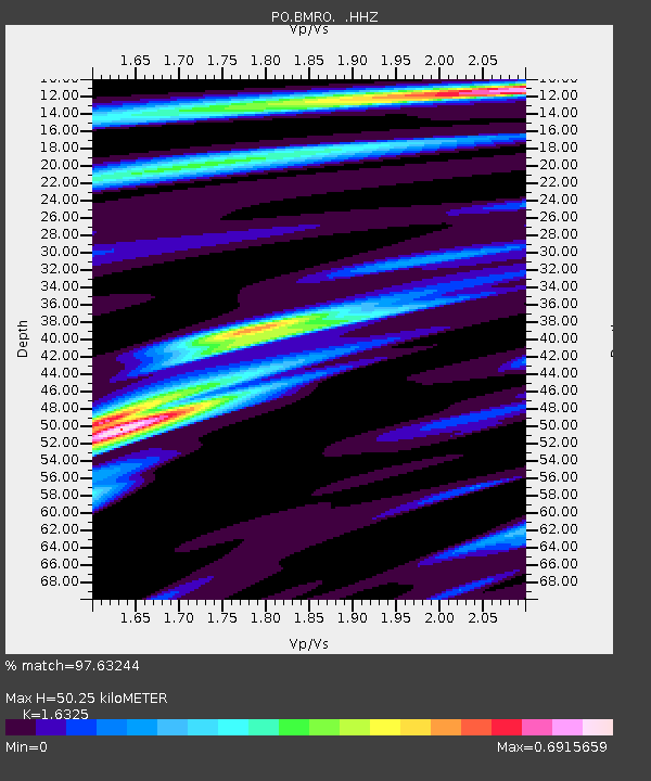
BMRO Maryville Lake, ON, CANADA.A - Earthquake Result Viewer

Earthquake location: Near Coast Of Peru
Earthquake latitude/longitude: -15.8/-74.5
Earthquake time(UTC): 2013/09/25 (268) 16:42:43 GMT
Earthquake Depth: 40 km
Earthquake Magnitude: 7.1 MWW, 6.8 MI, 7.0 MWB, 7.0 MWC, 7.1 MWW, 7.1 MWC
Earthquake Catalog/Contributor: NEIC PDE/NEIC COMCAT
Network: PO Portable Observatories for Lithospheric Analysis and Research Investigating Seis
Station: BMRO Maryville Lake, ON, CANADA.A
Lat/Lon: 44.60 N/81.22 W
Elevation: 217 m
Distance: 60.5 deg
Az: 354.497 deg
Baz: 172.576 deg
Ray Param: 0.061444785
Estimated Moho Depth: 50.25 km
Estimated Crust Vp/Vs: 1.63
Assumed Crust Vp: 6.53 km/s
Estimated Crust Vs: 4.0 km/s
Estimated Crust Poisson's Ratio: 0.20
Radial Match: 97.63244 %
Radial Bump: 290
Transverse Match: 70.72163 %
Transverse Bump: 400
SOD ConfigId: 626651
Insert Time: 2014-04-18 20:26:29.945 +0000
GWidth: 2.5
Max Bumps: 400
Tol: 0.001

Signal To Noise

ChannelStoNSTALTA
PO:BMRO: :HHZ:20130925T16:52:18.070024Z43.0043689.99564E-62.3243314E-7
PO:BMRO: :HHN:20130925T16:52:18.070024Z19.4819324.87343E-62.5015126E-7
PO:BMRO: :HHE:20130925T16:52:18.070024Z5.30955366.984545E-71.3154676E-7
Arrivals
Ps5.1 SECOND
PpPs19 SECOND
PsPs/PpSs24 SECOND