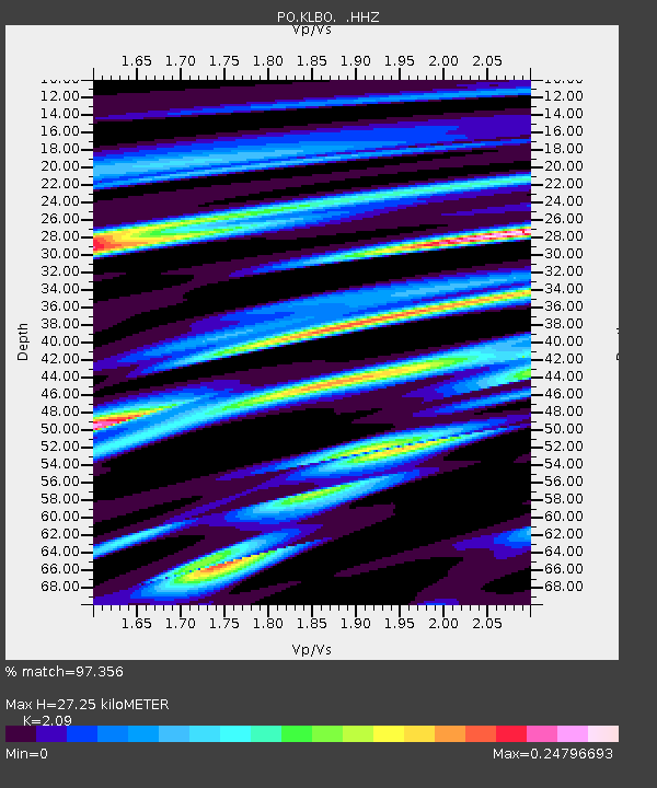
KLBO KILLBEAR, ON - Earthquake Result Viewer

Earthquake location: Near Coast Of Peru
Earthquake latitude/longitude: -15.8/-74.5
Earthquake time(UTC): 2013/09/25 (268) 16:42:43 GMT
Earthquake Depth: 40 km
Earthquake Magnitude: 7.1 MWW, 6.8 MI, 7.0 MWB, 7.0 MWC, 7.1 MWW, 7.1 MWC
Earthquake Catalog/Contributor: NEIC PDE/NEIC COMCAT
Network: PO Portable Observatories for Lithospheric Analysis and Research Investigating Seis
Station: KLBO KILLBEAR, ON
Lat/Lon: 45.36 N/80.21 W
Elevation: 177 m
Distance: 61.1 deg
Az: 355.411 deg
Baz: 173.73 deg
Ray Param: 0.061001796
Estimated Moho Depth: 27.25 km
Estimated Crust Vp/Vs: 2.09
Assumed Crust Vp: 6.53 km/s
Estimated Crust Vs: 3.125 km/s
Estimated Crust Poisson's Ratio: 0.35
Radial Match: 97.356 %
Radial Bump: 119
Transverse Match: 85.69624 %
Transverse Bump: 400
SOD ConfigId: 626651
Insert Time: 2014-04-18 20:26:57.243 +0000
GWidth: 2.5
Max Bumps: 400
Tol: 0.001

Signal To Noise

ChannelStoNSTALTA
PO:KLBO: :HHZ:20130925T16:52:22.620012Z24.8347473.7626837E-61.5150884E-7
PO:KLBO: :HHN:20130925T16:52:22.620012Z21.804651.8714687E-68.582889E-8
PO:KLBO: :HHE:20130925T16:52:22.620012Z1.94052461.513255E-77.7981746E-8
Arrivals
Ps4.7 SECOND
PpPs12 SECOND
PsPs/PpSs17 SECOND