You are here: Home > Network List > TA - USArray Transportable Network (new EarthScope stations) Stations List
> Station 058A Arcadia, FL, USA > Earthquake Result Viewer
058A Arcadia, FL, USA - Earthquake Result Viewer
| Earthquake location: |
Near Coast Of Peru |
| Earthquake latitude/longitude: |
-15.8/-74.5 |
| Earthquake time(UTC): |
2013/09/25 (268) 16:42:43 GMT |
| Earthquake Depth: |
40 km |
| Earthquake Magnitude: |
7.1 MWW, 6.8 MI, 7.0 MWB, 7.0 MWC, 7.1 MWW, 7.1 MWC |
| Earthquake Catalog/Contributor: |
NEIC PDE/NEIC COMCAT |
|
| Network: |
TA USArray Transportable Network (new EarthScope stations) |
| Station: |
058A Arcadia, FL, USA |
| Lat/Lon: |
27.06 N/81.80 W |
| Elevation: |
15 m |
|
| Distance: |
43.2 deg |
| Az: |
350.484 deg |
| Baz: |
169.722 deg |
| Ray Param: |
0.07259558 |
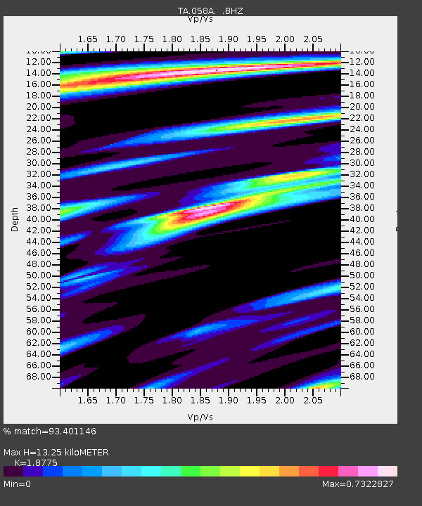
| Estimated Moho Depth: |
13.25 km |
| Estimated Crust Vp/Vs: |
1.88 |
| Assumed Crust Vp: |
6.347 km/s |
| Estimated Crust Vs: |
3.381 km/s |
| Estimated Crust Poisson's Ratio: |
0.30 |
|
| Radial Match: |
93.401146 % |
| Radial Bump: |
399 |
| Transverse Match: |
78.509445 % |
| Transverse Bump: |
400 |
| SOD ConfigId: |
626651 |
| Insert Time: |
2014-04-18 20:29:23.082 +0000 |
| GWidth: |
2.5 |
| Max Bumps: |
400 |
| Tol: |
0.001 |
|

Signal To Noise
| Channel | StoN | STA | LTA |
| TA:058A: :BHZ:20130925T16:50:09.974993Z | 4.1252313 | 5.3634753E-6 | 1.3001635E-6 |
| TA:058A: :BHN:20130925T16:50:09.974993Z | 3.678244 | 1.9180238E-6 | 5.2145094E-7 |
| TA:058A: :BHE:20130925T16:50:09.974993Z | 0.8116049 | 1.0190504E-6 | 1.255599E-6 |
| Arrivals |
| Ps | 1.9 SECOND |
| PpPs | 5.7 SECOND |
| PsPs/PpSs | 7.6 SECOND |


