You are here: Home > Network List > TA - USArray Transportable Network (new EarthScope stations) Stations List
> Station 059Z Ave Maria, FL, USA > Earthquake Result Viewer
059Z Ave Maria, FL, USA - Earthquake Result Viewer
| Earthquake location: |
Near Coast Of Peru |
| Earthquake latitude/longitude: |
-15.8/-74.5 |
| Earthquake time(UTC): |
2013/09/25 (268) 16:42:43 GMT |
| Earthquake Depth: |
40 km |
| Earthquake Magnitude: |
7.1 MWW, 6.8 MI, 7.0 MWB, 7.0 MWC, 7.1 MWW, 7.1 MWC |
| Earthquake Catalog/Contributor: |
NEIC PDE/NEIC COMCAT |
|
| Network: |
TA USArray Transportable Network (new EarthScope stations) |
| Station: |
059Z Ave Maria, FL, USA |
| Lat/Lon: |
26.34 N/81.44 W |
| Elevation: |
8.0 m |
|
| Distance: |
42.5 deg |
| Az: |
350.768 deg |
| Baz: |
170.091 deg |
| Ray Param: |
0.07307587 |
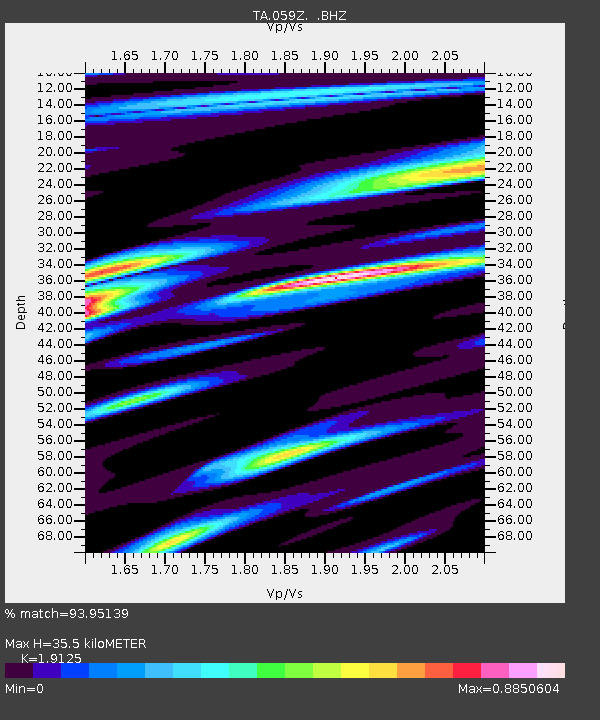
| Estimated Moho Depth: |
35.5 km |
| Estimated Crust Vp/Vs: |
1.91 |
| Assumed Crust Vp: |
6.347 km/s |
| Estimated Crust Vs: |
3.319 km/s |
| Estimated Crust Poisson's Ratio: |
0.31 |
|
| Radial Match: |
93.95139 % |
| Radial Bump: |
400 |
| Transverse Match: |
77.61166 % |
| Transverse Bump: |
400 |
| SOD ConfigId: |
626651 |
| Insert Time: |
2014-04-18 20:29:31.337 +0000 |
| GWidth: |
2.5 |
| Max Bumps: |
400 |
| Tol: |
0.001 |
|
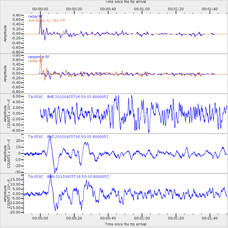
Signal To Noise
| Channel | StoN | STA | LTA |
| TA:059Z: :BHZ:20130925T16:50:03.800005Z | 4.0666256 | 4.486049E-6 | 1.103138E-6 |
| TA:059Z: :BHN:20130925T16:50:03.800005Z | 1.4070212 | 1.6220683E-6 | 1.1528386E-6 |
| TA:059Z: :BHE:20130925T16:50:03.800005Z | 0.8311112 | 1.2875864E-6 | 1.549235E-6 |
| Arrivals |
| Ps | 5.4 SECOND |
| PpPs | 15 SECOND |
| PsPs/PpSs | 21 SECOND |


