You are here: Home > Network List > TA - USArray Transportable Network (new EarthScope stations) Stations List
> Station 060Z West Palm Beach, FL, USA > Earthquake Result Viewer
060Z West Palm Beach, FL, USA - Earthquake Result Viewer
| Earthquake location: |
Near Coast Of Peru |
| Earthquake latitude/longitude: |
-15.8/-74.5 |
| Earthquake time(UTC): |
2013/09/25 (268) 16:42:43 GMT |
| Earthquake Depth: |
40 km |
| Earthquake Magnitude: |
7.1 MWW, 6.8 MI, 7.0 MWB, 7.0 MWC, 7.1 MWW, 7.1 MWC |
| Earthquake Catalog/Contributor: |
NEIC PDE/NEIC COMCAT |
|
| Network: |
TA USArray Transportable Network (new EarthScope stations) |
| Station: |
060Z West Palm Beach, FL, USA |
| Lat/Lon: |
26.41 N/80.56 W |
| Elevation: |
9.0 m |
|
| Distance: |
42.4 deg |
| Az: |
351.949 deg |
| Baz: |
171.355 deg |
| Ray Param: |
0.07311064 |
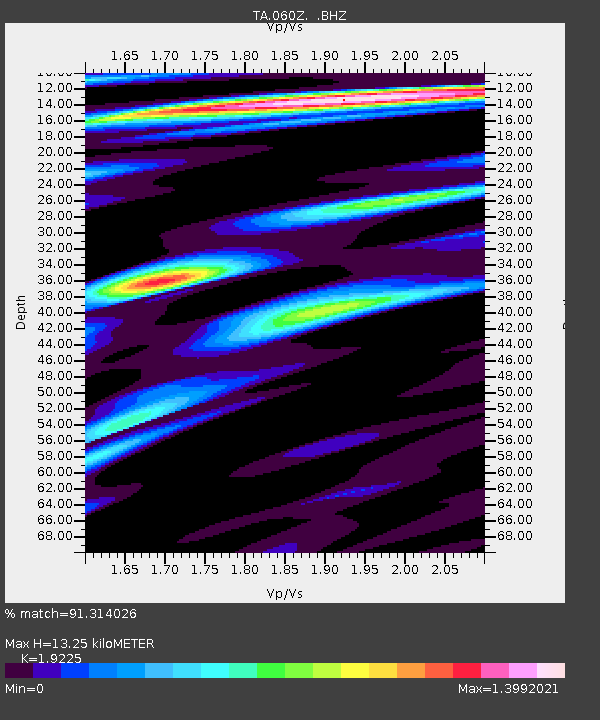
| Estimated Moho Depth: |
13.25 km |
| Estimated Crust Vp/Vs: |
1.92 |
| Assumed Crust Vp: |
6.347 km/s |
| Estimated Crust Vs: |
3.301 km/s |
| Estimated Crust Poisson's Ratio: |
0.31 |
|
| Radial Match: |
91.314026 % |
| Radial Bump: |
400 |
| Transverse Match: |
65.446815 % |
| Transverse Bump: |
400 |
| SOD ConfigId: |
626651 |
| Insert Time: |
2014-04-18 20:29:42.912 +0000 |
| GWidth: |
2.5 |
| Max Bumps: |
400 |
| Tol: |
0.001 |
|
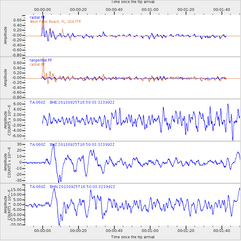
Signal To Noise
| Channel | StoN | STA | LTA |
| TA:060Z: :BHZ:20130925T16:50:03.323992Z | 5.189968 | 3.1294906E-6 | 6.029884E-7 |
| TA:060Z: :BHN:20130925T16:50:03.323992Z | 1.6621376 | 1.4349264E-6 | 8.633018E-7 |
| TA:060Z: :BHE:20130925T16:50:03.323992Z | 1.1321397 | 1.0801251E-6 | 9.540564E-7 |
| Arrivals |
| Ps | 2.0 SECOND |
| PpPs | 5.7 SECOND |
| PsPs/PpSs | 7.8 SECOND |


