You are here: Home > Network List > TA - USArray Transportable Network (new EarthScope stations) Stations List
> Station 061Z Ochoppi, FL, USA > Earthquake Result Viewer
061Z Ochoppi, FL, USA - Earthquake Result Viewer
| Earthquake location: |
Near Coast Of Peru |
| Earthquake latitude/longitude: |
-15.8/-74.5 |
| Earthquake time(UTC): |
2013/09/25 (268) 16:42:43 GMT |
| Earthquake Depth: |
40 km |
| Earthquake Magnitude: |
7.1 MWW, 6.8 MI, 7.0 MWB, 7.0 MWC, 7.1 MWW, 7.1 MWC |
| Earthquake Catalog/Contributor: |
NEIC PDE/NEIC COMCAT |
|
| Network: |
TA USArray Transportable Network (new EarthScope stations) |
| Station: |
061Z Ochoppi, FL, USA |
| Lat/Lon: |
25.87 N/80.91 W |
| Elevation: |
9.0 m |
|
| Distance: |
41.9 deg |
| Az: |
351.36 deg |
| Baz: |
170.764 deg |
| Ray Param: |
0.073391095 |
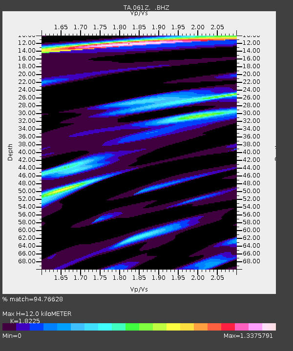
| Estimated Moho Depth: |
12.0 km |
| Estimated Crust Vp/Vs: |
1.82 |
| Assumed Crust Vp: |
5.78 km/s |
| Estimated Crust Vs: |
3.171 km/s |
| Estimated Crust Poisson's Ratio: |
0.28 |
|
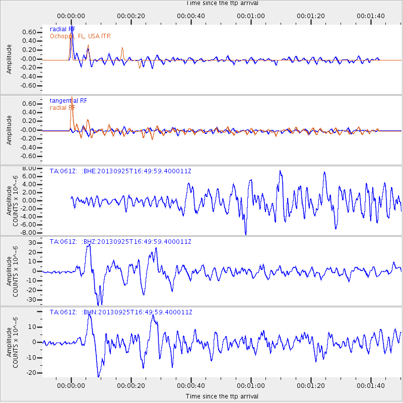
| Radial Match: |
94.76628 % |
| Radial Bump: |
400 |
| Transverse Match: |
80.789566 % |
| Transverse Bump: |
400 |
| SOD ConfigId: |
626651 |
| Insert Time: |
2014-04-18 20:29:47.852 +0000 |
| GWidth: |
2.5 |
| Max Bumps: |
400 |
| Tol: |
0.001 |
|
Signal To Noise
| Channel | StoN | STA | LTA |
| TA:061Z: :BHZ:20130925T16:49:59.400011Z | 7.6709576 | 4.0647446E-6 | 5.298875E-7 |
| TA:061Z: :BHN:20130925T16:49:59.400011Z | 2.1377268 | 1.8344047E-6 | 8.5811E-7 |
| TA:061Z: :BHE:20130925T16:49:59.400011Z | 0.96165705 | 7.487587E-7 | 7.78613E-7 |
| Arrivals |
| Ps | 1.8 SECOND |
| PpPs | 5.6 SECOND |
| PsPs/PpSs | 7.4 SECOND |


