You are here: Home > Network List > TA - USArray Transportable Network (new EarthScope stations) Stations List
> Station 157A Early Branch, SC, USA > Earthquake Result Viewer
157A Early Branch, SC, USA - Earthquake Result Viewer
| Earthquake location: |
Near Coast Of Peru |
| Earthquake latitude/longitude: |
-15.8/-74.5 |
| Earthquake time(UTC): |
2013/09/25 (268) 16:42:43 GMT |
| Earthquake Depth: |
40 km |
| Earthquake Magnitude: |
7.1 MWW, 6.8 MI, 7.0 MWB, 7.0 MWC, 7.1 MWW, 7.1 MWC |
| Earthquake Catalog/Contributor: |
NEIC PDE/NEIC COMCAT |
|
| Network: |
TA USArray Transportable Network (new EarthScope stations) |
| Station: |
157A Early Branch, SC, USA |
| Lat/Lon: |
32.68 N/81.00 W |
| Elevation: |
21 m |
|
| Distance: |
48.6 deg |
| Az: |
352.708 deg |
| Baz: |
171.671 deg |
| Ray Param: |
0.06913519 |
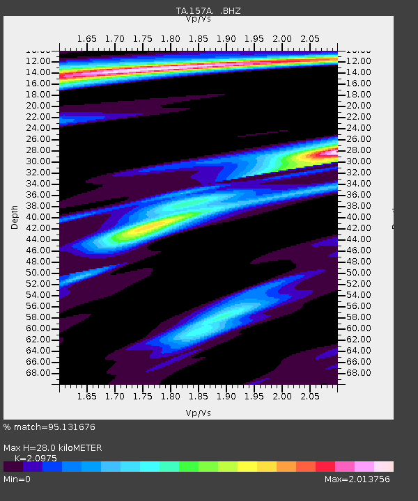
| Estimated Moho Depth: |
28.0 km |
| Estimated Crust Vp/Vs: |
2.10 |
| Assumed Crust Vp: |
6.565 km/s |
| Estimated Crust Vs: |
3.13 km/s |
| Estimated Crust Poisson's Ratio: |
0.35 |
|
| Radial Match: |
95.131676 % |
| Radial Bump: |
270 |
| Transverse Match: |
87.8438 % |
| Transverse Bump: |
400 |
| SOD ConfigId: |
626651 |
| Insert Time: |
2014-04-18 20:30:15.792 +0000 |
| GWidth: |
2.5 |
| Max Bumps: |
400 |
| Tol: |
0.001 |
|

Signal To Noise
| Channel | StoN | STA | LTA |
| TA:157A: :BHZ:20130925T16:50:52.573992Z | 5.7029266 | 3.786426E-6 | 6.639444E-7 |
| TA:157A: :BHN:20130925T16:50:52.573992Z | 2.1948183 | 2.431544E-6 | 1.1078567E-6 |
| TA:157A: :BHE:20130925T16:50:52.573992Z | 1.8638678 | 1.484005E-6 | 7.961965E-7 |
| Arrivals |
| Ps | 4.9 SECOND |
| PpPs | 13 SECOND |
| PsPs/PpSs | 17 SECOND |


