You are here: Home > Network List > TA - USArray Transportable Network (new EarthScope stations) Stations List
> Station 250A Grady, AL, USA > Earthquake Result Viewer
250A Grady, AL, USA - Earthquake Result Viewer
| Earthquake location: |
Near Coast Of Peru |
| Earthquake latitude/longitude: |
-15.8/-74.5 |
| Earthquake time(UTC): |
2013/09/25 (268) 16:42:43 GMT |
| Earthquake Depth: |
40 km |
| Earthquake Magnitude: |
7.1 MWW, 6.8 MI, 7.0 MWB, 7.0 MWC, 7.1 MWW, 7.1 MWC |
| Earthquake Catalog/Contributor: |
NEIC PDE/NEIC COMCAT |
|
| Network: |
TA USArray Transportable Network (new EarthScope stations) |
| Station: |
250A Grady, AL, USA |
| Lat/Lon: |
31.98 N/86.27 W |
| Elevation: |
152 m |
|
| Distance: |
48.9 deg |
| Az: |
346.708 deg |
| Baz: |
164.906 deg |
| Ray Param: |
0.06898639 |
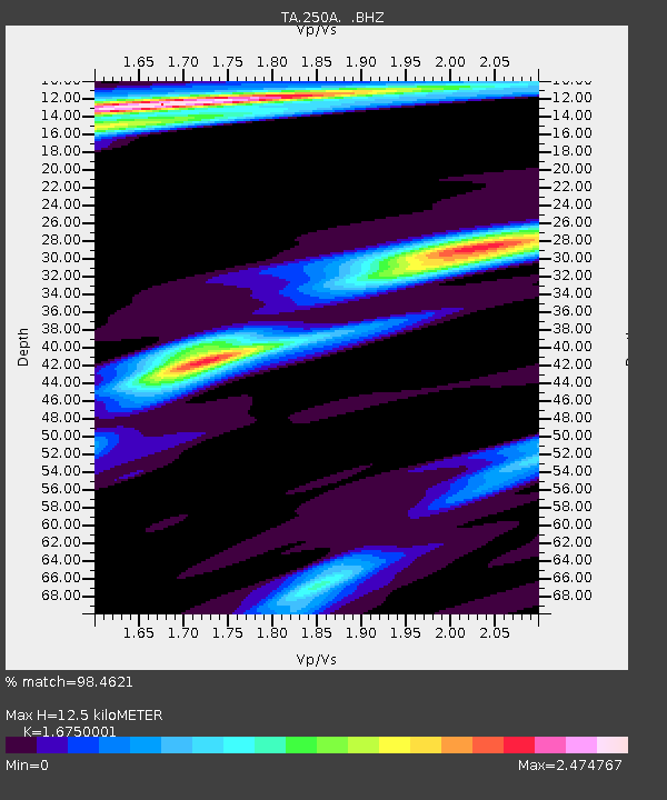
| Estimated Moho Depth: |
12.5 km |
| Estimated Crust Vp/Vs: |
1.68 |
| Assumed Crust Vp: |
6.187 km/s |
| Estimated Crust Vs: |
3.694 km/s |
| Estimated Crust Poisson's Ratio: |
0.22 |
|
| Radial Match: |
98.4621 % |
| Radial Bump: |
276 |
| Transverse Match: |
94.35027 % |
| Transverse Bump: |
400 |
| SOD ConfigId: |
626651 |
| Insert Time: |
2014-04-18 20:30:30.237 +0000 |
| GWidth: |
2.5 |
| Max Bumps: |
400 |
| Tol: |
0.001 |
|

Signal To Noise
| Channel | StoN | STA | LTA |
| TA:250A: :BHZ:20130925T16:50:54.274004Z | 72.23166 | 1.1720601E-5 | 1.6226403E-7 |
| TA:250A: :BHN:20130925T16:50:54.274004Z | 10.12899 | 3.910106E-6 | 3.8603116E-7 |
| TA:250A: :BHE:20130925T16:50:54.274004Z | 2.0183847 | 1.2124184E-6 | 6.006875E-7 |
| Arrivals |
| Ps | 1.4 SECOND |
| PpPs | 5.1 SECOND |
| PsPs/PpSs | 6.5 SECOND |


