You are here: Home > Network List > TA - USArray Transportable Network (new EarthScope stations) Stations List
> Station 253A Americus, GA, USA > Earthquake Result Viewer
253A Americus, GA, USA - Earthquake Result Viewer
| Earthquake location: |
Near Coast Of Peru |
| Earthquake latitude/longitude: |
-15.8/-74.5 |
| Earthquake time(UTC): |
2013/09/25 (268) 16:42:43 GMT |
| Earthquake Depth: |
40 km |
| Earthquake Magnitude: |
7.1 MWW, 6.8 MI, 7.0 MWB, 7.0 MWC, 7.1 MWW, 7.1 MWC |
| Earthquake Catalog/Contributor: |
NEIC PDE/NEIC COMCAT |
|
| Network: |
TA USArray Transportable Network (new EarthScope stations) |
| Station: |
253A Americus, GA, USA |
| Lat/Lon: |
32.06 N/84.13 W |
| Elevation: |
136 m |
|
| Distance: |
48.5 deg |
| Az: |
349.083 deg |
| Baz: |
167.603 deg |
| Ray Param: |
0.06922072 |
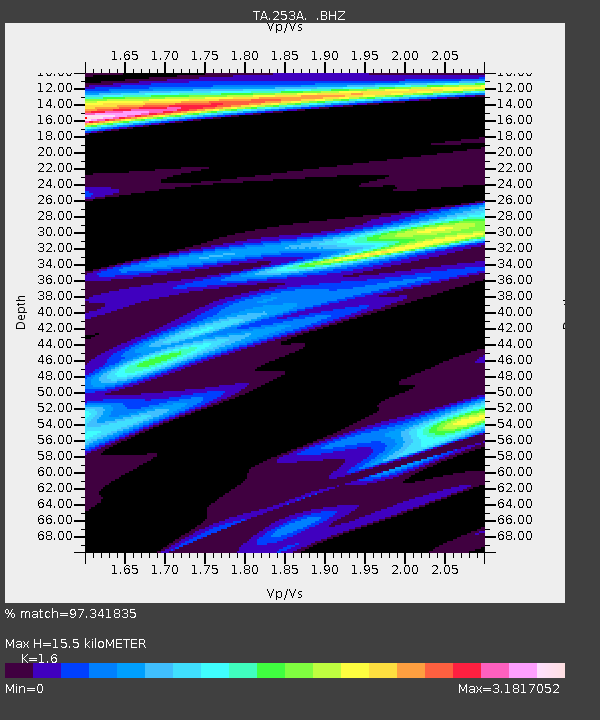
| Estimated Moho Depth: |
15.5 km |
| Estimated Crust Vp/Vs: |
1.60 |
| Assumed Crust Vp: |
6.719 km/s |
| Estimated Crust Vs: |
4.2 km/s |
| Estimated Crust Poisson's Ratio: |
0.18 |
|
| Radial Match: |
97.341835 % |
| Radial Bump: |
370 |
| Transverse Match: |
90.230995 % |
| Transverse Bump: |
400 |
| SOD ConfigId: |
626651 |
| Insert Time: |
2014-04-18 20:30:35.984 +0000 |
| GWidth: |
2.5 |
| Max Bumps: |
400 |
| Tol: |
0.001 |
|

Signal To Noise
| Channel | StoN | STA | LTA |
| TA:253A: :BHZ:20130925T16:50:51.574999Z | 25.843933 | 1.1807241E-5 | 4.5686707E-7 |
| TA:253A: :BHN:20130925T16:50:51.574999Z | 5.6247115 | 3.7517582E-6 | 6.670134E-7 |
| TA:253A: :BHE:20130925T16:50:51.574999Z | 1.7988611 | 1.2008758E-6 | 6.6757565E-7 |
| Arrivals |
| Ps | 1.5 SECOND |
| PpPs | 5.6 SECOND |
| PsPs/PpSs | 7.1 SECOND |


