You are here: Home > Network List > AF - Africa Array Stations List
> Station TEBE Entebbe, Uganda > Earthquake Result Viewer
TEBE Entebbe, Uganda - Earthquake Result Viewer
| Earthquake location: |
Northern Molucca Sea |
| Earthquake latitude/longitude: |
1.9/126.5 |
| Earthquake time(UTC): |
2014/11/26 (330) 14:33:43 GMT |
| Earthquake Depth: |
39 km |
| Earthquake Magnitude: |
6.8 MWW, 6.8 MWC, 6.8 MWB, 7.0 MI |
| Earthquake Catalog/Contributor: |
NEIC PDE/NEIC COMCAT |
|
| Network: |
AF Africa Array |
| Station: |
TEBE Entebbe, Uganda |
| Lat/Lon: |
0.05 N/32.48 E |
| Elevation: |
1132 m |
|
| Distance: |
94.0 deg |
| Az: |
270.188 deg |
| Baz: |
88.081 deg |
| Ray Param: |
0.04111887 |
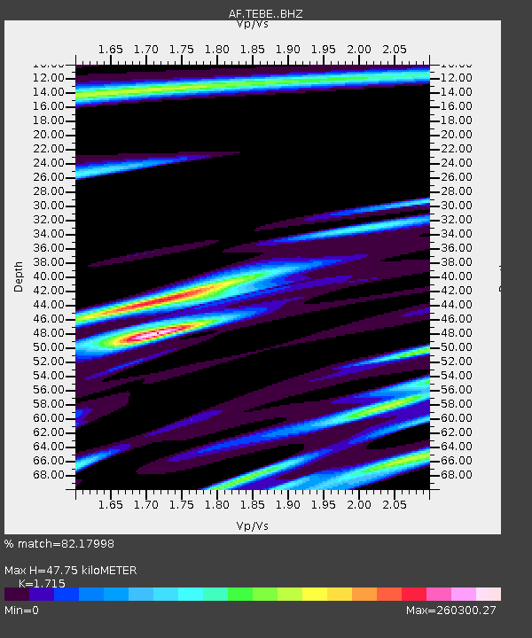
| Estimated Moho Depth: |
47.75 km |
| Estimated Crust Vp/Vs: |
1.72 |
| Assumed Crust Vp: |
6.642 km/s |
| Estimated Crust Vs: |
3.873 km/s |
| Estimated Crust Poisson's Ratio: |
0.24 |
|
| Radial Match: |
82.17998 % |
| Radial Bump: |
382 |
| Transverse Match: |
82.17989 % |
| Transverse Bump: |
382 |
| SOD ConfigId: |
3390531 |
| Insert Time: |
2019-04-15 04:57:55.299 +0000 |
| GWidth: |
2.5 |
| Max Bumps: |
400 |
| Tol: |
0.001 |
|

Signal To Noise
| Channel | StoN | STA | LTA |
| AF:TEBE: :BHZ:20141126T14:46:26.664993Z | 0.77850646 | 2.3668187E-11 | 3.0402042E-11 |
| AF:TEBE: :BHN:20141126T14:46:26.664993Z | 1.171136 | 7.223269E-12 | 6.167745E-12 |
| AF:TEBE: :BHE:20141126T14:46:26.664993Z | 0.81275 | 8.927095E-6 | 1.0983815E-5 |
| Arrivals |
| Ps | 5.3 SECOND |
| PpPs | 19 SECOND |
| PsPs/PpSs | 24 SECOND |


