You are here: Home > Network List > TA - USArray Transportable Network (new EarthScope stations) Stations List
> Station 454A Quitman, GA, USA > Earthquake Result Viewer
454A Quitman, GA, USA - Earthquake Result Viewer
| Earthquake location: |
Near Coast Of Peru |
| Earthquake latitude/longitude: |
-15.8/-74.5 |
| Earthquake time(UTC): |
2013/09/25 (268) 16:42:43 GMT |
| Earthquake Depth: |
40 km |
| Earthquake Magnitude: |
7.1 MWW, 6.8 MI, 7.0 MWB, 7.0 MWC, 7.1 MWW, 7.1 MWC |
| Earthquake Catalog/Contributor: |
NEIC PDE/NEIC COMCAT |
|
| Network: |
TA USArray Transportable Network (new EarthScope stations) |
| Station: |
454A Quitman, GA, USA |
| Lat/Lon: |
30.71 N/83.63 W |
| Elevation: |
50 m |
|
| Distance: |
47.1 deg |
| Az: |
349.263 deg |
| Baz: |
167.982 deg |
| Ray Param: |
0.070115365 |
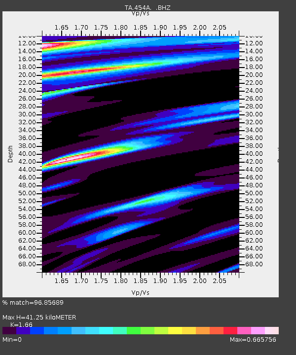
| Estimated Moho Depth: |
41.25 km |
| Estimated Crust Vp/Vs: |
1.66 |
| Assumed Crust Vp: |
6.565 km/s |
| Estimated Crust Vs: |
3.955 km/s |
| Estimated Crust Poisson's Ratio: |
0.22 |
|
| Radial Match: |
96.85689 % |
| Radial Bump: |
273 |
| Transverse Match: |
92.41704 % |
| Transverse Bump: |
372 |
| SOD ConfigId: |
626651 |
| Insert Time: |
2014-04-18 20:31:26.299 +0000 |
| GWidth: |
2.5 |
| Max Bumps: |
400 |
| Tol: |
0.001 |
|
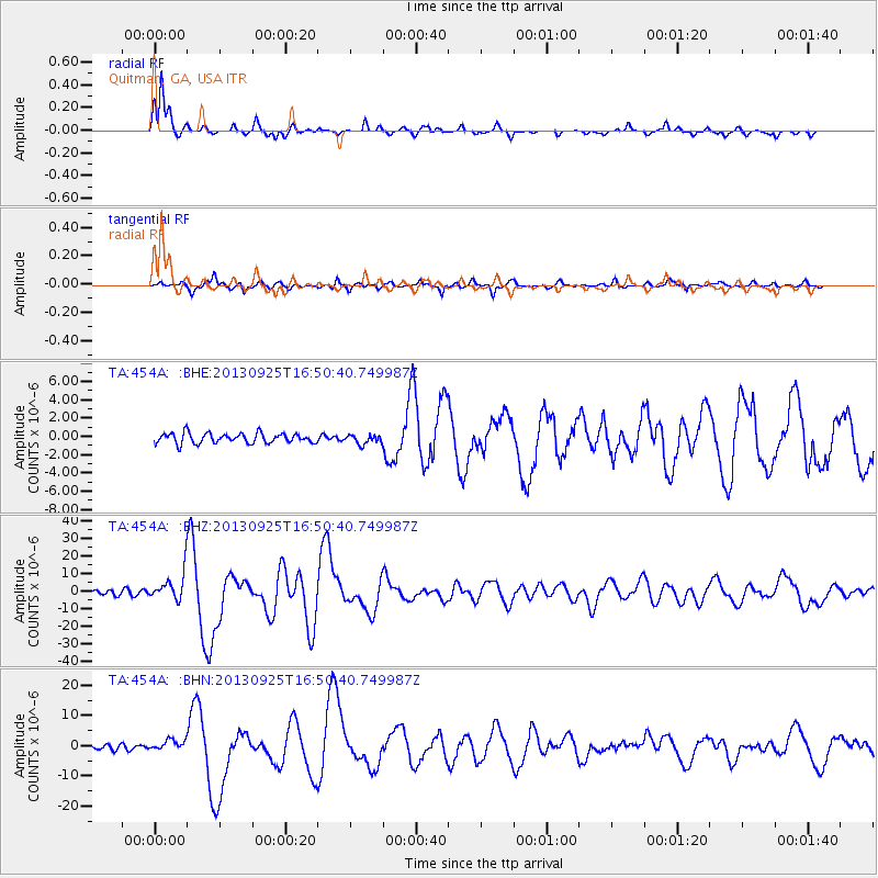
Signal To Noise
| Channel | StoN | STA | LTA |
| TA:454A: :BHZ:20130925T16:50:40.749987Z | 6.6777534 | 7.7519135E-6 | 1.1608564E-6 |
| TA:454A: :BHN:20130925T16:50:40.749987Z | 1.7894002 | 1.7918695E-6 | 1.0013799E-6 |
| TA:454A: :BHE:20130925T16:50:40.749987Z | 0.9190511 | 5.068868E-7 | 5.5153276E-7 |
| Arrivals |
| Ps | 4.4 SECOND |
| PpPs | 16 SECOND |
| PsPs/PpSs | 20 SECOND |


