You are here: Home > Network List > AK - Alaska Regional Network Stations List
> Station HIN Hinchinbrook, AK, USA > Earthquake Result Viewer
HIN Hinchinbrook, AK, USA - Earthquake Result Viewer
| Earthquake location: |
Northern Molucca Sea |
| Earthquake latitude/longitude: |
1.9/126.5 |
| Earthquake time(UTC): |
2014/11/26 (330) 14:33:43 GMT |
| Earthquake Depth: |
39 km |
| Earthquake Magnitude: |
6.8 MWW, 6.8 MWC, 6.8 MWB, 7.0 MI |
| Earthquake Catalog/Contributor: |
NEIC PDE/NEIC COMCAT |
|
| Network: |
AK Alaska Regional Network |
| Station: |
HIN Hinchinbrook, AK, USA |
| Lat/Lon: |
60.40 N/146.50 W |
| Elevation: |
623 m |
|
| Distance: |
86.8 deg |
| Az: |
29.774 deg |
| Baz: |
268.315 deg |
| Ray Param: |
0.04370463 |
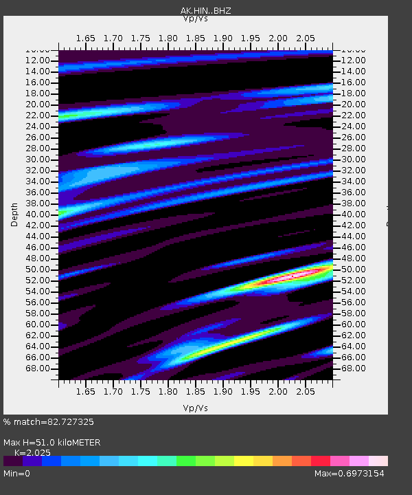
| Estimated Moho Depth: |
51.0 km |
| Estimated Crust Vp/Vs: |
2.03 |
| Assumed Crust Vp: |
6.566 km/s |
| Estimated Crust Vs: |
3.243 km/s |
| Estimated Crust Poisson's Ratio: |
0.34 |
|
| Radial Match: |
82.727325 % |
| Radial Bump: |
400 |
| Transverse Match: |
77.95128 % |
| Transverse Bump: |
400 |
| SOD ConfigId: |
3390531 |
| Insert Time: |
2019-04-15 04:58:01.675 +0000 |
| GWidth: |
2.5 |
| Max Bumps: |
400 |
| Tol: |
0.001 |
|

Signal To Noise
| Channel | StoN | STA | LTA |
| AK:HIN: :BHZ:20141126T14:45:53.367996Z | 9.801634 | 2.91459E-6 | 2.9735756E-7 |
| AK:HIN: :BHN:20141126T14:45:53.367996Z | 0.94180065 | 3.6026913E-7 | 3.8253225E-7 |
| AK:HIN: :BHE:20141126T14:45:53.367996Z | 2.947846 | 8.1369404E-7 | 2.7603005E-7 |
| Arrivals |
| Ps | 8.1 SECOND |
| PpPs | 23 SECOND |
| PsPs/PpSs | 31 SECOND |


