You are here: Home > Network List > TA - USArray Transportable Network (new EarthScope stations) Stations List
> Station 557A Orange Park, FL, USA > Earthquake Result Viewer
557A Orange Park, FL, USA - Earthquake Result Viewer

| Earthquake location: |
Near Coast Of Peru |
| Earthquake latitude/longitude: |
-15.8/-74.5 |
| Earthquake time(UTC): |
2013/09/25 (268) 16:42:43 GMT |
| Earthquake Depth: |
40 km |
| Earthquake Magnitude: |
7.1 MWW, 6.8 MI, 7.0 MWB, 7.0 MWC, 7.1 MWW, 7.1 MWC |
| Earthquake Catalog/Contributor: |
NEIC PDE/NEIC COMCAT |
|
| Network: |
TA USArray Transportable Network (new EarthScope stations) |
| Station: |
557A Orange Park, FL, USA |
| Lat/Lon: |
30.02 N/81.73 W |
| Elevation: |
24 m |
|
| Distance: |
46.1 deg |
| Az: |
351.304 deg |
| Baz: |
170.341 deg |
| Ray Param: |
0.070755534 |
| Estimated Moho Depth: |
33.75 km |
| Estimated Crust Vp/Vs: |
1.93 |
| Assumed Crust Vp: |
5.989 km/s |
| Estimated Crust Vs: |
3.095 km/s |
| Estimated Crust Poisson's Ratio: |
0.32 |
|
| Radial Match: |
93.64892 % |
| Radial Bump: |
349 |
| Transverse Match: |
76.34266 % |
| Transverse Bump: |
400 |
| SOD ConfigId: |
626651 |
| Insert Time: |
2014-04-18 20:31:46.548 +0000 |
| GWidth: |
2.5 |
| Max Bumps: |
400 |
| Tol: |
0.001 |
|
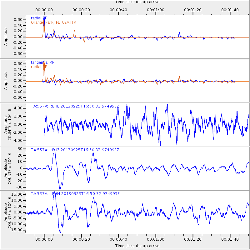
Signal To Noise
| Channel | StoN | STA | LTA |
| TA:557A: :BHZ:20130925T16:50:32.974993Z | 9.22082 | 5.715518E-6 | 6.198492E-7 |
| TA:557A: :BHN:20130925T16:50:32.974993Z | 3.0563161 | 2.4931085E-6 | 8.1572335E-7 |
| TA:557A: :BHE:20130925T16:50:32.974993Z | 0.5948199 | 5.3305365E-7 | 8.9615975E-7 |
| Arrivals |
| Ps | 5.5 SECOND |
| PpPs | 16 SECOND |
| PsPs/PpSs | 21 SECOND |


