You are here: Home > Network List > TA - USArray Transportable Network (new EarthScope stations) Stations List
> Station 553A Crawfordville, FL, USA > Earthquake Result Viewer
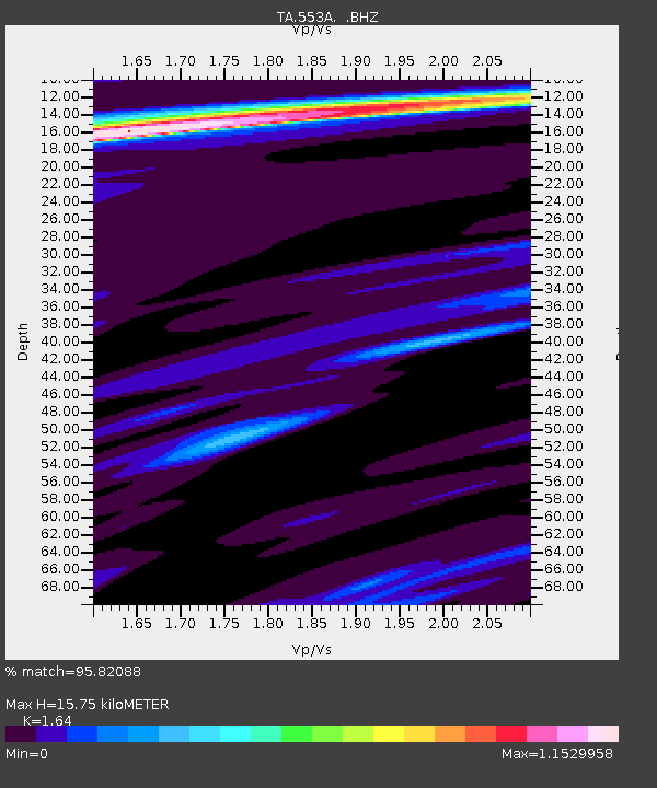
553A Crawfordville, FL, USA - Earthquake Result Viewer
| Earthquake location: |
Near Coast Of Peru |
| Earthquake latitude/longitude: |
-15.8/-74.5 |
| Earthquake time(UTC): |
2013/09/25 (268) 16:42:43 GMT |
| Earthquake Depth: |
40 km |
| Earthquake Magnitude: |
7.1 MWW, 6.8 MI, 7.0 MWB, 7.0 MWC, 7.1 MWW, 7.1 MWC |
| Earthquake Catalog/Contributor: |
NEIC PDE/NEIC COMCAT |
|
| Network: |
TA USArray Transportable Network (new EarthScope stations) |
| Station: |
553A Crawfordville, FL, USA |
| Lat/Lon: |
30.19 N/84.43 W |
| Elevation: |
16 m |
|
| Distance: |
46.7 deg |
| Az: |
348.182 deg |
| Baz: |
166.84 deg |
| Ray Param: |
0.07035501 |
| Estimated Moho Depth: |
15.75 km |
| Estimated Crust Vp/Vs: |
1.64 |
| Assumed Crust Vp: |
6.347 km/s |
| Estimated Crust Vs: |
3.87 km/s |
| Estimated Crust Poisson's Ratio: |
0.20 |
|
| Radial Match: |
95.82088 % |
| Radial Bump: |
366 |
| Transverse Match: |
95.52734 % |
| Transverse Bump: |
400 |
| SOD ConfigId: |
626651 |
| Insert Time: |
2014-04-18 20:31:46.921 +0000 |
| GWidth: |
2.5 |
| Max Bumps: |
400 |
| Tol: |
0.001 |
|

Signal To Noise
| Channel | StoN | STA | LTA |
| TA:553A: :BHZ:20130925T16:50:37.925005Z | 7.046253 | 7.1332092E-6 | 1.0123408E-6 |
| TA:553A: :BHN:20130925T16:50:37.925005Z | 3.2790496 | 2.875908E-6 | 8.770553E-7 |
| TA:553A: :BHE:20130925T16:50:37.925005Z | 1.8463937 | 1.0281744E-6 | 5.5685547E-7 |
| Arrivals |
| Ps | 1.7 SECOND |
| PpPs | 6.1 SECOND |
| PsPs/PpSs | 7.8 SECOND |


