You are here: Home > Network List > TA - USArray Transportable Network (new EarthScope stations) Stations List
> Station D04E Lakebay, WA, USA > Earthquake Result Viewer
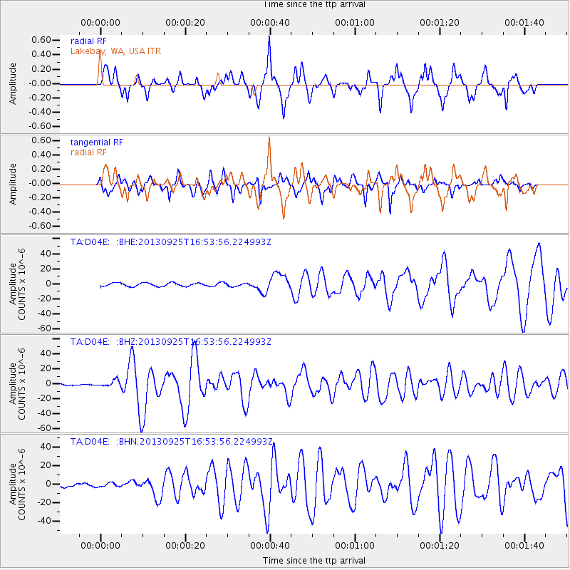
D04E Lakebay, WA, USA - Earthquake Result Viewer
*The percent match for this event was below the threshold and hence no stack was calculated.
| Earthquake location: |
Near Coast Of Peru |
| Earthquake latitude/longitude: |
-15.8/-74.5 |
| Earthquake time(UTC): |
2013/09/25 (268) 16:42:43 GMT |
| Earthquake Depth: |
40 km |
| Earthquake Magnitude: |
7.1 MWW, 6.8 MI, 7.0 MWB, 7.0 MWC, 7.1 MWW, 7.1 MWC |
| Earthquake Catalog/Contributor: |
NEIC PDE/NEIC COMCAT |
|
| Network: |
TA USArray Transportable Network (new EarthScope stations) |
| Station: |
D04E Lakebay, WA, USA |
| Lat/Lon: |
47.18 N/122.77 W |
| Elevation: |
45 m |
|
| Distance: |
76.2 deg |
| Az: |
328.387 deg |
| Baz: |
132.302 deg |
| Ray Param: |
$rayparam |
*The percent match for this event was below the threshold and hence was not used in the summary stack. |
|
| Radial Match: |
83.53622 % |
| Radial Bump: |
400 |
| Transverse Match: |
83.57386 % |
| Transverse Bump: |
378 |
| SOD ConfigId: |
626651 |
| Insert Time: |
2014-04-18 20:32:35.795 +0000 |
| GWidth: |
2.5 |
| Max Bumps: |
400 |
| Tol: |
0.001 |
|
Signal To Noise
| Channel | StoN | STA | LTA |
| TA:D04E: :BHZ:20130925T16:53:56.224993Z | 3.235192 | 4.321821E-6 | 1.3358778E-6 |
| TA:D04E: :BHN:20130925T16:53:56.224993Z | 0.8931461 | 2.0009036E-6 | 2.240287E-6 |
| TA:D04E: :BHE:20130925T16:53:56.224993Z | 0.95240724 | 2.150375E-6 | 2.2578315E-6 |
| Arrivals |
| Ps | |
| PpPs | |
| PsPs/PpSs | |


