You are here: Home > Network List > TA - USArray Transportable Network (new EarthScope stations) Stations List
> Station D46A Sault St. Marie, ON, CAN > Earthquake Result Viewer
D46A Sault St. Marie, ON, CAN - Earthquake Result Viewer

| Earthquake location: |
Near Coast Of Peru |
| Earthquake latitude/longitude: |
-15.8/-74.5 |
| Earthquake time(UTC): |
2013/09/25 (268) 16:42:43 GMT |
| Earthquake Depth: |
40 km |
| Earthquake Magnitude: |
7.1 MWW, 6.8 MI, 7.0 MWB, 7.0 MWC, 7.1 MWW, 7.1 MWC |
| Earthquake Catalog/Contributor: |
NEIC PDE/NEIC COMCAT |
|
| Network: |
TA USArray Transportable Network (new EarthScope stations) |
| Station: |
D46A Sault St. Marie, ON, CAN |
| Lat/Lon: |
46.89 N/84.04 W |
| Elevation: |
353 m |
|
| Distance: |
63.0 deg |
| Az: |
352.684 deg |
| Baz: |
169.705 deg |
| Ray Param: |
0.059770565 |
| Estimated Moho Depth: |
31.0 km |
| Estimated Crust Vp/Vs: |
2.01 |
| Assumed Crust Vp: |
6.467 km/s |
| Estimated Crust Vs: |
3.213 km/s |
| Estimated Crust Poisson's Ratio: |
0.34 |
|
| Radial Match: |
98.594246 % |
| Radial Bump: |
202 |
| Transverse Match: |
94.77761 % |
| Transverse Bump: |
289 |
| SOD ConfigId: |
626651 |
| Insert Time: |
2014-04-18 20:32:44.756 +0000 |
| GWidth: |
2.5 |
| Max Bumps: |
400 |
| Tol: |
0.001 |
|
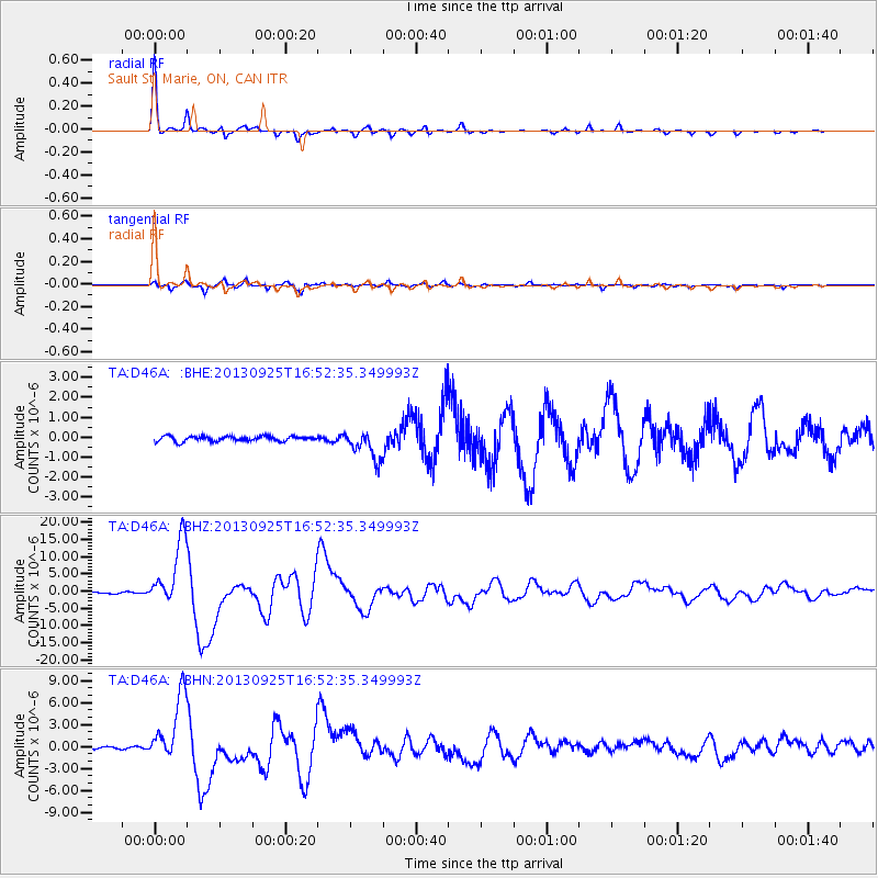
Signal To Noise
| Channel | StoN | STA | LTA |
| TA:D46A: :BHZ:20130925T16:52:35.349993Z | 45.17194 | 9.5332725E-6 | 2.1104412E-7 |
| TA:D46A: :BHN:20130925T16:52:35.349993Z | 21.642324 | 4.5450843E-6 | 2.1000908E-7 |
| TA:D46A: :BHE:20130925T16:52:35.349993Z | 5.7597704 | 7.278334E-7 | 1.2636501E-7 |
| Arrivals |
| Ps | 5.0 SECOND |
| PpPs | 14 SECOND |
| PsPs/PpSs | 19 SECOND |


