You are here: Home > Network List > TA - USArray Transportable Network (new EarthScope stations) Stations List
> Station D50A G1974 Best Township, ON, CAN > Earthquake Result Viewer
D50A G1974 Best Township, ON, CAN - Earthquake Result Viewer

| Earthquake location: |
Near Coast Of Peru |
| Earthquake latitude/longitude: |
-15.8/-74.5 |
| Earthquake time(UTC): |
2013/09/25 (268) 16:42:43 GMT |
| Earthquake Depth: |
40 km |
| Earthquake Magnitude: |
7.1 MWW, 6.8 MI, 7.0 MWB, 7.0 MWC, 7.1 MWW, 7.1 MWC |
| Earthquake Catalog/Contributor: |
NEIC PDE/NEIC COMCAT |
|
| Network: |
TA USArray Transportable Network (new EarthScope stations) |
| Station: |
D50A G1974 Best Township, ON, CAN |
| Lat/Lon: |
47.17 N/79.84 W |
| Elevation: |
331 m |
|
| Distance: |
62.9 deg |
| Az: |
355.917 deg |
| Baz: |
174.235 deg |
| Ray Param: |
0.05985315 |
| Estimated Moho Depth: |
33.5 km |
| Estimated Crust Vp/Vs: |
1.72 |
| Assumed Crust Vp: |
6.622 km/s |
| Estimated Crust Vs: |
3.845 km/s |
| Estimated Crust Poisson's Ratio: |
0.25 |
|
| Radial Match: |
98.19265 % |
| Radial Bump: |
299 |
| Transverse Match: |
88.634026 % |
| Transverse Bump: |
400 |
| SOD ConfigId: |
626651 |
| Insert Time: |
2014-04-18 20:32:55.463 +0000 |
| GWidth: |
2.5 |
| Max Bumps: |
400 |
| Tol: |
0.001 |
|
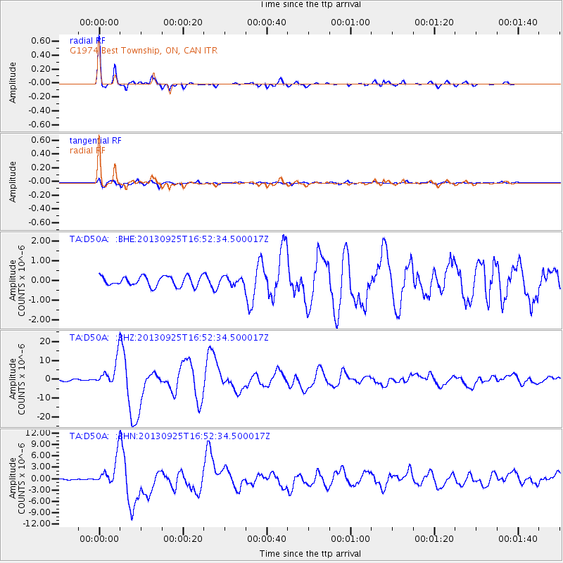
Signal To Noise
| Channel | StoN | STA | LTA |
| TA:D50A: :BHZ:20130925T16:52:34.500017Z | 16.730755 | 7.604885E-6 | 4.5454524E-7 |
| TA:D50A: :BHN:20130925T16:52:34.500017Z | 30.41273 | 4.072969E-6 | 1.3392318E-7 |
| TA:D50A: :BHE:20130925T16:52:34.500017Z | 0.79055357 | 1.9530002E-7 | 2.470421E-7 |
| Arrivals |
| Ps | 3.8 SECOND |
| PpPs | 13 SECOND |
| PsPs/PpSs | 17 SECOND |


