You are here: Home > Network List > TA - USArray Transportable Network (new EarthScope stations) Stations List
> Station D56A ZEC Mazanza, Mont-Saint-Michel, QC, CAN > Earthquake Result Viewer
D56A ZEC Mazanza, Mont-Saint-Michel, QC, CAN - Earthquake Result Viewer

| Earthquake location: |
Near Coast Of Peru |
| Earthquake latitude/longitude: |
-15.8/-74.5 |
| Earthquake time(UTC): |
2013/09/25 (268) 16:42:43 GMT |
| Earthquake Depth: |
40 km |
| Earthquake Magnitude: |
7.1 MWW, 6.8 MI, 7.0 MWB, 7.0 MWC, 7.1 MWW, 7.1 MWC |
| Earthquake Catalog/Contributor: |
NEIC PDE/NEIC COMCAT |
|
| Network: |
TA USArray Transportable Network (new EarthScope stations) |
| Station: |
D56A ZEC Mazanza, Mont-Saint-Michel, QC, CAN |
| Lat/Lon: |
47.05 N/74.76 W |
| Elevation: |
421 m |
|
| Distance: |
62.6 deg |
| Az: |
359.811 deg |
| Baz: |
179.734 deg |
| Ray Param: |
0.06004769 |
| Estimated Moho Depth: |
39.25 km |
| Estimated Crust Vp/Vs: |
1.71 |
| Assumed Crust Vp: |
6.61 km/s |
| Estimated Crust Vs: |
3.86 km/s |
| Estimated Crust Poisson's Ratio: |
0.24 |
|
| Radial Match: |
98.455246 % |
| Radial Bump: |
159 |
| Transverse Match: |
93.0112 % |
| Transverse Bump: |
400 |
| SOD ConfigId: |
626651 |
| Insert Time: |
2014-04-18 20:33:16.745 +0000 |
| GWidth: |
2.5 |
| Max Bumps: |
400 |
| Tol: |
0.001 |
|
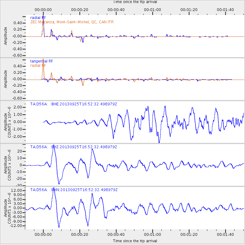
Signal To Noise
| Channel | StoN | STA | LTA |
| TA:D56A: :BHZ:20130925T16:52:32.498979Z | 13.398645 | 3.8067424E-6 | 2.8411398E-7 |
| TA:D56A: :BHN:20130925T16:52:32.498979Z | 3.8685434 | 1.6635478E-6 | 4.3001916E-7 |
| TA:D56A: :BHE:20130925T16:52:32.498979Z | 2.4488072 | 3.2714053E-7 | 1.335918E-7 |
| Arrivals |
| Ps | 4.4 SECOND |
| PpPs | 15 SECOND |
| PsPs/PpSs | 20 SECOND |


