You are here: Home > Network List > TA - USArray Transportable Network (new EarthScope stations) Stations List
> Station E44A Grand Marais Airport, Grand Marais, MI, USA > Earthquake Result Viewer
E44A Grand Marais Airport, Grand Marais, MI, USA - Earthquake Result Viewer
| Earthquake location: |
Near Coast Of Peru |
| Earthquake latitude/longitude: |
-15.8/-74.5 |
| Earthquake time(UTC): |
2013/09/25 (268) 16:42:43 GMT |
| Earthquake Depth: |
40 km |
| Earthquake Magnitude: |
7.1 MWW, 6.8 MI, 7.0 MWB, 7.0 MWC, 7.1 MWW, 7.1 MWC |
| Earthquake Catalog/Contributor: |
NEIC PDE/NEIC COMCAT |
|
| Network: |
TA USArray Transportable Network (new EarthScope stations) |
| Station: |
E44A Grand Marais Airport, Grand Marais, MI, USA |
| Lat/Lon: |
46.62 N/85.92 W |
| Elevation: |
282 m |
|
| Distance: |
63.0 deg |
| Az: |
351.198 deg |
| Baz: |
167.662 deg |
| Ray Param: |
0.059777997 |
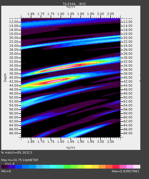
| Estimated Moho Depth: |
34.75 km |
| Estimated Crust Vp/Vs: |
1.80 |
| Assumed Crust Vp: |
6.467 km/s |
| Estimated Crust Vs: |
3.593 km/s |
| Estimated Crust Poisson's Ratio: |
0.28 |
|
| Radial Match: |
95.38313 % |
| Radial Bump: |
340 |
| Transverse Match: |
88.84544 % |
| Transverse Bump: |
400 |
| SOD ConfigId: |
626651 |
| Insert Time: |
2014-04-18 20:33:56.093 +0000 |
| GWidth: |
2.5 |
| Max Bumps: |
400 |
| Tol: |
0.001 |
|
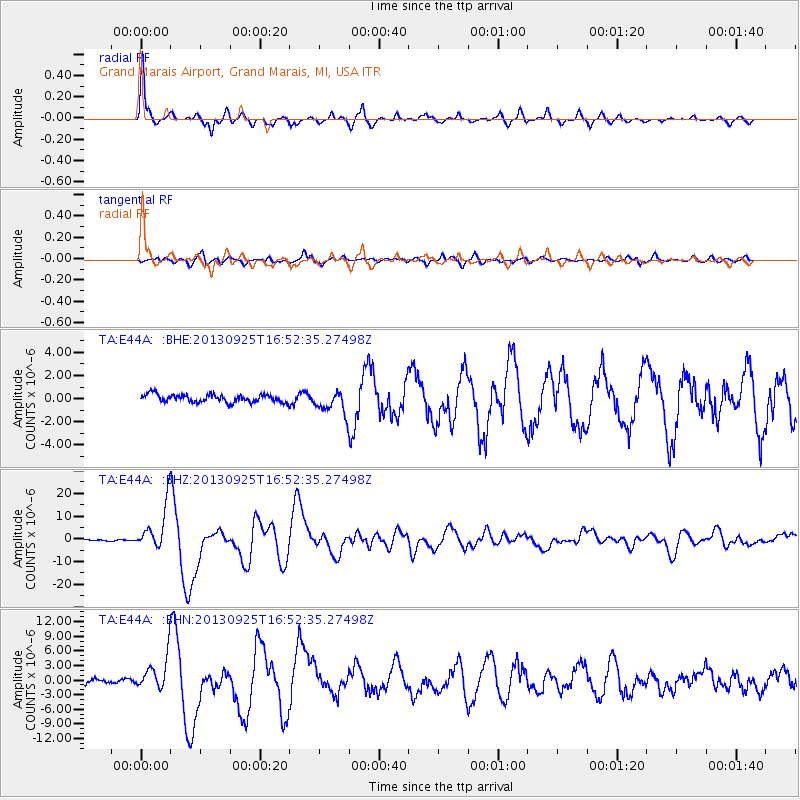
Signal To Noise
| Channel | StoN | STA | LTA |
| TA:E44A: :BHZ:20130925T16:52:35.27498Z | 30.033634 | 9.819348E-6 | 3.2694504E-7 |
| TA:E44A: :BHN:20130925T16:52:35.27498Z | 6.88303 | 3.3801573E-6 | 4.9108564E-7 |
| TA:E44A: :BHE:20130925T16:52:35.27498Z | 2.9324176 | 9.986817E-7 | 3.4056598E-7 |
| Arrivals |
| Ps | 4.5 SECOND |
| PpPs | 14 SECOND |
| PsPs/PpSs | 19 SECOND |


