You are here: Home > Network List > TA - USArray Transportable Network (new EarthScope stations) Stations List
> Station E50A Wahnapitae, ON, CAN > Earthquake Result Viewer
E50A Wahnapitae, ON, CAN - Earthquake Result Viewer
| Earthquake location: |
Near Coast Of Peru |
| Earthquake latitude/longitude: |
-15.8/-74.5 |
| Earthquake time(UTC): |
2013/09/25 (268) 16:42:43 GMT |
| Earthquake Depth: |
40 km |
| Earthquake Magnitude: |
7.1 MWW, 6.8 MI, 7.0 MWB, 7.0 MWC, 7.1 MWW, 7.1 MWC |
| Earthquake Catalog/Contributor: |
NEIC PDE/NEIC COMCAT |
|
| Network: |
TA USArray Transportable Network (new EarthScope stations) |
| Station: |
E50A Wahnapitae, ON, CAN |
| Lat/Lon: |
46.42 N/80.74 W |
| Elevation: |
242 m |
|
| Distance: |
62.2 deg |
| Az: |
355.136 deg |
| Baz: |
173.224 deg |
| Ray Param: |
0.060290836 |
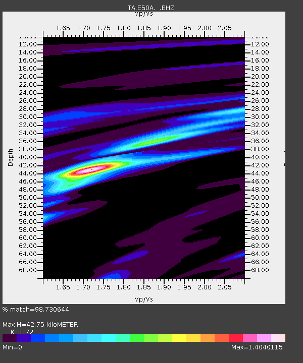
| Estimated Moho Depth: |
42.75 km |
| Estimated Crust Vp/Vs: |
1.72 |
| Assumed Crust Vp: |
6.467 km/s |
| Estimated Crust Vs: |
3.76 km/s |
| Estimated Crust Poisson's Ratio: |
0.24 |
|
| Radial Match: |
98.730644 % |
| Radial Bump: |
250 |
| Transverse Match: |
90.646515 % |
| Transverse Bump: |
377 |
| SOD ConfigId: |
626651 |
| Insert Time: |
2014-04-18 20:34:08.864 +0000 |
| GWidth: |
2.5 |
| Max Bumps: |
400 |
| Tol: |
0.001 |
|

Signal To Noise
| Channel | StoN | STA | LTA |
| TA:E50A: :BHZ:20130925T16:52:30.02498Z | 51.12058 | 8.409224E-6 | 1.6449783E-7 |
| TA:E50A: :BHN:20130925T16:52:30.02498Z | 21.153667 | 5.466669E-6 | 2.5842652E-7 |
| TA:E50A: :BHE:20130925T16:52:30.02498Z | 5.710388 | 6.4592837E-7 | 1.13114616E-7 |
| Arrivals |
| Ps | 5.0 SECOND |
| PpPs | 17 SECOND |
| PsPs/PpSs | 22 SECOND |


