You are here: Home > Network List > TA - USArray Transportable Network (new EarthScope stations) Stations List
> Station E56A St. Veronique, QC, CAN > Earthquake Result Viewer
E56A St. Veronique, QC, CAN - Earthquake Result Viewer
| Earthquake location: |
Near Coast Of Peru |
| Earthquake latitude/longitude: |
-15.8/-74.5 |
| Earthquake time(UTC): |
2013/09/25 (268) 16:42:43 GMT |
| Earthquake Depth: |
40 km |
| Earthquake Magnitude: |
7.1 MWW, 6.8 MI, 7.0 MWB, 7.0 MWC, 7.1 MWW, 7.1 MWC |
| Earthquake Catalog/Contributor: |
NEIC PDE/NEIC COMCAT |
|
| Network: |
TA USArray Transportable Network (new EarthScope stations) |
| Station: |
E56A St. Veronique, QC, CAN |
| Lat/Lon: |
46.54 N/75.03 W |
| Elevation: |
320 m |
|
| Distance: |
62.1 deg |
| Az: |
359.592 deg |
| Baz: |
179.43 deg |
| Ray Param: |
0.06037841 |
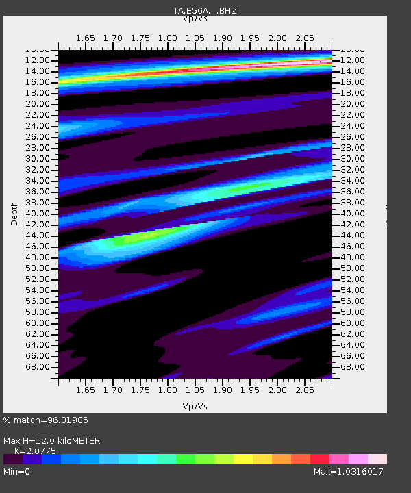
| Estimated Moho Depth: |
12.0 km |
| Estimated Crust Vp/Vs: |
2.08 |
| Assumed Crust Vp: |
6.61 km/s |
| Estimated Crust Vs: |
3.182 km/s |
| Estimated Crust Poisson's Ratio: |
0.35 |
|
| Radial Match: |
96.31905 % |
| Radial Bump: |
287 |
| Transverse Match: |
83.175446 % |
| Transverse Bump: |
400 |
| SOD ConfigId: |
626651 |
| Insert Time: |
2014-04-18 20:34:31.008 +0000 |
| GWidth: |
2.5 |
| Max Bumps: |
400 |
| Tol: |
0.001 |
|
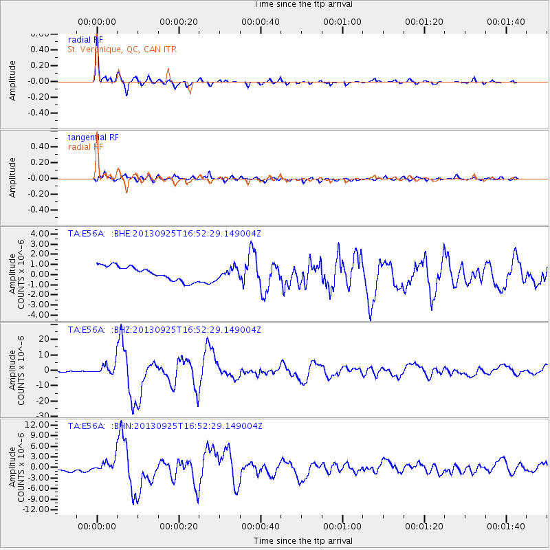
Signal To Noise
| Channel | StoN | STA | LTA |
| TA:E56A: :BHZ:20130925T16:52:29.149004Z | 18.737164 | 3.943413E-6 | 2.1045945E-7 |
| TA:E56A: :BHN:20130925T16:52:29.149004Z | 2.3564446 | 1.7454377E-6 | 7.407081E-7 |
| TA:E56A: :BHE:20130925T16:52:29.149004Z | 0.66741395 | 4.6538685E-7 | 6.972987E-7 |
| Arrivals |
| Ps | 2.0 SECOND |
| PpPs | 5.4 SECOND |
| PsPs/PpSs | 7.4 SECOND |


