You are here: Home > Network List > TA - USArray Transportable Network (new EarthScope stations) Stations List
> Station E60A Ste Agathe de Lotbiniere, QC, CAN > Earthquake Result Viewer
E60A Ste Agathe de Lotbiniere, QC, CAN - Earthquake Result Viewer
| Earthquake location: |
Near Coast Of Peru |
| Earthquake latitude/longitude: |
-15.8/-74.5 |
| Earthquake time(UTC): |
2013/09/25 (268) 16:42:43 GMT |
| Earthquake Depth: |
40 km |
| Earthquake Magnitude: |
7.1 MWW, 6.8 MI, 7.0 MWB, 7.0 MWC, 7.1 MWW, 7.1 MWC |
| Earthquake Catalog/Contributor: |
NEIC PDE/NEIC COMCAT |
|
| Network: |
TA USArray Transportable Network (new EarthScope stations) |
| Station: |
E60A Ste Agathe de Lotbiniere, QC, CAN |
| Lat/Lon: |
46.37 N/71.45 W |
| Elevation: |
181 m |
|
| Distance: |
62.0 deg |
| Az: |
2.403 deg |
| Baz: |
183.341 deg |
| Ray Param: |
0.060454246 |
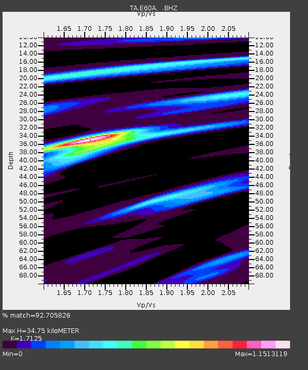
| Estimated Moho Depth: |
34.75 km |
| Estimated Crust Vp/Vs: |
1.71 |
| Assumed Crust Vp: |
6.61 km/s |
| Estimated Crust Vs: |
3.86 km/s |
| Estimated Crust Poisson's Ratio: |
0.24 |
|
| Radial Match: |
92.705826 % |
| Radial Bump: |
373 |
| Transverse Match: |
77.04959 % |
| Transverse Bump: |
400 |
| SOD ConfigId: |
626651 |
| Insert Time: |
2014-04-18 20:34:37.400 +0000 |
| GWidth: |
2.5 |
| Max Bumps: |
400 |
| Tol: |
0.001 |
|
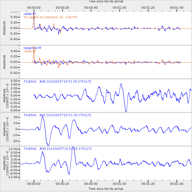
Signal To Noise
| Channel | StoN | STA | LTA |
| TA:E60A: :BHZ:20130925T16:52:28.375017Z | 3.2399058 | 2.2192908E-6 | 6.8498616E-7 |
| TA:E60A: :BHN:20130925T16:52:28.375017Z | 3.0743377 | 1.1442784E-6 | 3.722032E-7 |
| TA:E60A: :BHE:20130925T16:52:28.375017Z | 1.2577775 | 5.200506E-7 | 4.134679E-7 |
| Arrivals |
| Ps | 3.9 SECOND |
| PpPs | 14 SECOND |
| PsPs/PpSs | 18 SECOND |


