You are here: Home > Network List > TA - USArray Transportable Network (new EarthScope stations) Stations List
> Station E63A Oxbow, ME, USA > Earthquake Result Viewer
E63A Oxbow, ME, USA - Earthquake Result Viewer
| Earthquake location: |
Near Coast Of Peru |
| Earthquake latitude/longitude: |
-15.8/-74.5 |
| Earthquake time(UTC): |
2013/09/25 (268) 16:42:43 GMT |
| Earthquake Depth: |
40 km |
| Earthquake Magnitude: |
7.1 MWW, 6.8 MI, 7.0 MWB, 7.0 MWC, 7.1 MWW, 7.1 MWC |
| Earthquake Catalog/Contributor: |
NEIC PDE/NEIC COMCAT |
|
| Network: |
TA USArray Transportable Network (new EarthScope stations) |
| Station: |
E63A Oxbow, ME, USA |
| Lat/Lon: |
46.42 N/68.42 W |
| Elevation: |
238 m |
|
| Distance: |
62.2 deg |
| Az: |
4.758 deg |
| Baz: |
186.627 deg |
| Ray Param: |
0.060298957 |
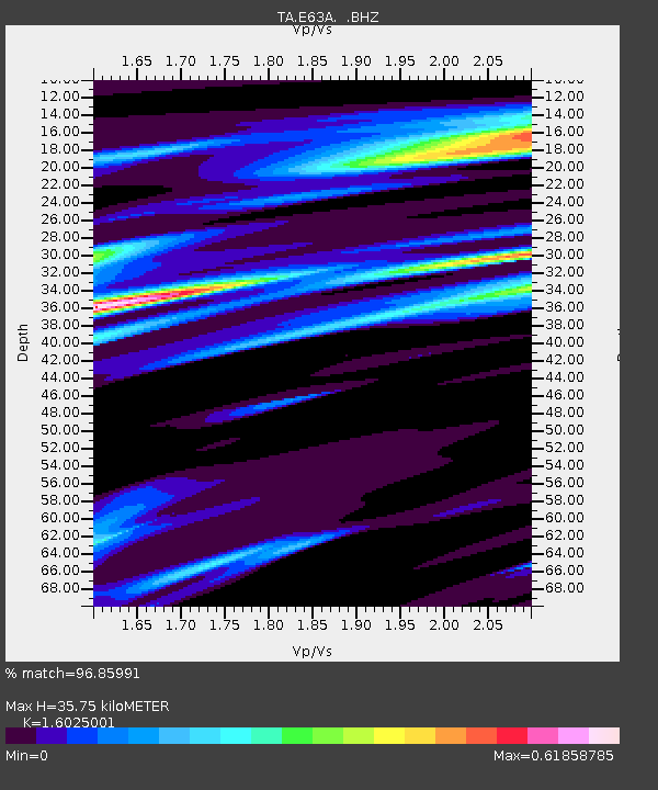
| Estimated Moho Depth: |
35.75 km |
| Estimated Crust Vp/Vs: |
1.60 |
| Assumed Crust Vp: |
6.419 km/s |
| Estimated Crust Vs: |
4.006 km/s |
| Estimated Crust Poisson's Ratio: |
0.18 |
|
| Radial Match: |
96.85991 % |
| Radial Bump: |
318 |
| Transverse Match: |
84.88978 % |
| Transverse Bump: |
400 |
| SOD ConfigId: |
626651 |
| Insert Time: |
2014-04-18 20:34:42.298 +0000 |
| GWidth: |
2.5 |
| Max Bumps: |
400 |
| Tol: |
0.001 |
|

Signal To Noise
| Channel | StoN | STA | LTA |
| TA:E63A: :BHZ:20130925T16:52:29.950029Z | 4.7995415 | 2.0998755E-6 | 4.3751584E-7 |
| TA:E63A: :BHN:20130925T16:52:29.950029Z | 3.1822267 | 9.110987E-7 | 2.8630856E-7 |
| TA:E63A: :BHE:20130925T16:52:29.950029Z | 1.4872764 | 4.7996383E-7 | 3.2271328E-7 |
| Arrivals |
| Ps | 3.5 SECOND |
| PpPs | 14 SECOND |
| PsPs/PpSs | 17 SECOND |


