You are here: Home > Network List > NY - Yukon Northwest Seismic Network(YNSN) Stations List
> Station WTLY Watson Lake, Yukon, CANADA > Earthquake Result Viewer
WTLY Watson Lake, Yukon, CANADA - Earthquake Result Viewer
| Earthquake location: |
Northern Molucca Sea |
| Earthquake latitude/longitude: |
1.9/126.5 |
| Earthquake time(UTC): |
2014/11/26 (330) 14:33:43 GMT |
| Earthquake Depth: |
39 km |
| Earthquake Magnitude: |
6.8 MWW, 6.8 MWC, 6.8 MWB, 7.0 MI |
| Earthquake Catalog/Contributor: |
NEIC PDE/NEIC COMCAT |
|
| Network: |
NY Yukon Northwest Seismic Network(YNSN) |
| Station: |
WTLY Watson Lake, Yukon, CANADA |
| Lat/Lon: |
60.11 N/128.80 W |
| Elevation: |
0.0 m |
|
| Distance: |
95.6 deg |
| Az: |
29.131 deg |
| Baz: |
283.708 deg |
| Ray Param: |
0.040714756 |
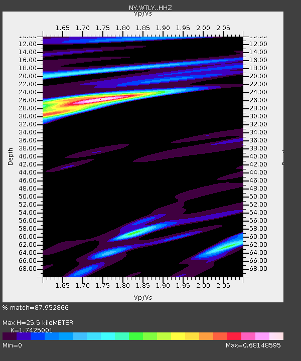
| Estimated Moho Depth: |
25.5 km |
| Estimated Crust Vp/Vs: |
1.74 |
| Assumed Crust Vp: |
6.35 km/s |
| Estimated Crust Vs: |
3.644 km/s |
| Estimated Crust Poisson's Ratio: |
0.25 |
|
| Radial Match: |
87.952866 % |
| Radial Bump: |
313 |
| Transverse Match: |
72.80543 % |
| Transverse Bump: |
400 |
| SOD ConfigId: |
3390531 |
| Insert Time: |
2019-04-15 04:59:19.062 +0000 |
| GWidth: |
2.5 |
| Max Bumps: |
400 |
| Tol: |
0.001 |
|

Signal To Noise
| Channel | StoN | STA | LTA |
| NY:WTLY: :HHZ:20141126T14:46:34.08998Z | 2.460051 | 6.269173E-7 | 2.5483914E-7 |
| NY:WTLY: :HHN:20141126T14:46:34.08998Z | 1.4359509 | 2.6841082E-7 | 1.8692202E-7 |
| NY:WTLY: :HHE:20141126T14:46:34.08998Z | 2.9540122 | 7.297012E-7 | 2.4702035E-7 |
| Arrivals |
| Ps | 3.0 SECOND |
| PpPs | 11 SECOND |
| PsPs/PpSs | 14 SECOND |


