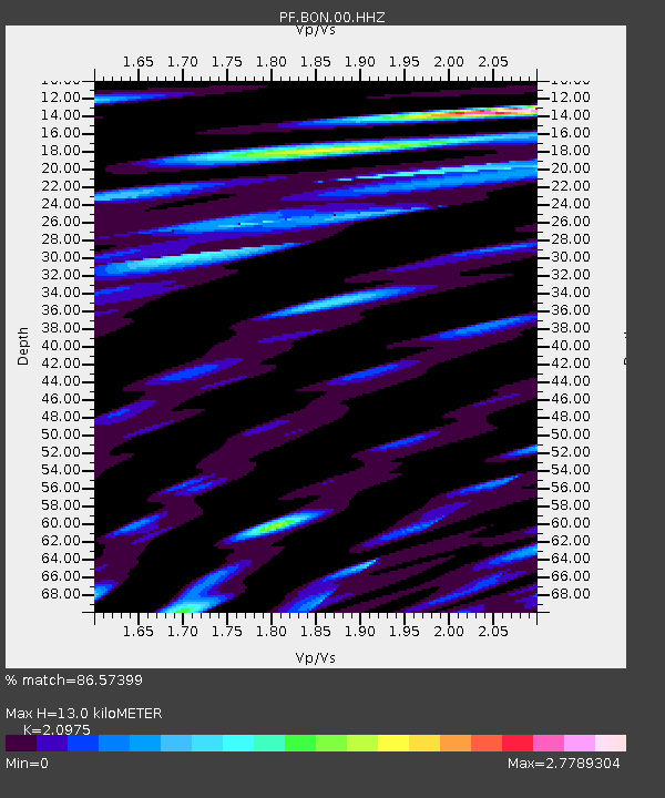
BON Bory Nord - Earthquake Result Viewer
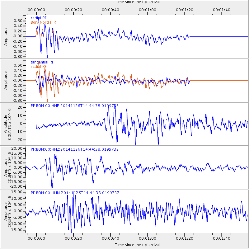
Earthquake location: Northern Molucca Sea
Earthquake latitude/longitude: 1.9/126.5
Earthquake time(UTC): 2014/11/26 (330) 14:33:43 GMT
Earthquake Depth: 39 km
Earthquake Magnitude: 6.8 MWW, 6.8 MWC, 6.8 MWB, 7.0 MI
Earthquake Catalog/Contributor: NEIC PDE/NEIC COMCAT
Network: PF Volcanologic Network of Piton de Fournaise-OVPF
Station: BON Bory Nord
Lat/Lon: 21.24 S/55.71 E
Elevation: 2552 m
Distance: 72.9 deg
Az: 247.212 deg
Baz: 81.01 deg
Ray Param: 0.053303756
Estimated Moho Depth: 13.0 km
Estimated Crust Vp/Vs: 2.10
Assumed Crust Vp: 4.73 km/s
Estimated Crust Vs: 2.255 km/s
Estimated Crust Poisson's Ratio: 0.35
Radial Match: 86.57399 %
Radial Bump: 400
Transverse Match: 61.60978 %
Transverse Bump: 400
SOD ConfigId: 3390531
Insert Time: 2019-04-15 04:59:22.063 +0000
GWidth: 2.5
Max Bumps: 400
Tol: 0.001

Signal To Noise

ChannelStoNSTALTA
PF:BON:00:HHZ:20141126T14:44:38.019973Z3.34160472.201225E-66.587329E-7
PF:BON:00:HHN:20141126T14:44:38.019973Z0.78277041.3326902E-61.7025302E-6
PF:BON:00:HHE:20141126T14:44:38.019973Z1.49416672.9088924E-61.9468325E-6
Arrivals
Ps3.1 SECOND
PpPs8.4 SECOND
PsPs/PpSs11 SECOND