You are here: Home > Network List > TA - USArray Transportable Network (new EarthScope stations) Stations List
> Station F57A Harrington, QC, CAN > Earthquake Result Viewer
F57A Harrington, QC, CAN - Earthquake Result Viewer
| Earthquake location: |
Near Coast Of Peru |
| Earthquake latitude/longitude: |
-15.8/-74.5 |
| Earthquake time(UTC): |
2013/09/25 (268) 16:42:43 GMT |
| Earthquake Depth: |
40 km |
| Earthquake Magnitude: |
7.1 MWW, 6.8 MI, 7.0 MWB, 7.0 MWC, 7.1 MWW, 7.1 MWC |
| Earthquake Catalog/Contributor: |
NEIC PDE/NEIC COMCAT |
|
| Network: |
TA USArray Transportable Network (new EarthScope stations) |
| Station: |
F57A Harrington, QC, CAN |
| Lat/Lon: |
45.81 N/74.69 W |
| Elevation: |
178 m |
|
| Distance: |
61.4 deg |
| Az: |
359.855 deg |
| Baz: |
179.801 deg |
| Ray Param: |
0.060848955 |
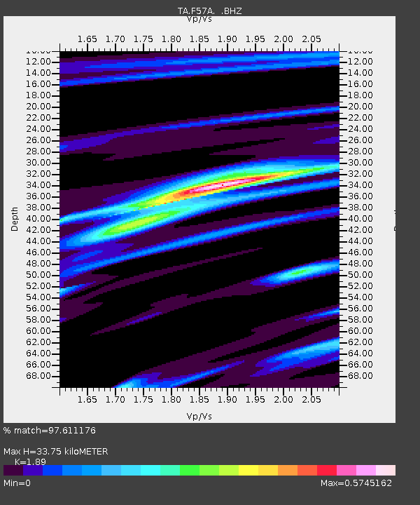
| Estimated Moho Depth: |
33.75 km |
| Estimated Crust Vp/Vs: |
1.89 |
| Assumed Crust Vp: |
6.419 km/s |
| Estimated Crust Vs: |
3.396 km/s |
| Estimated Crust Poisson's Ratio: |
0.31 |
|
| Radial Match: |
97.611176 % |
| Radial Bump: |
261 |
| Transverse Match: |
90.843376 % |
| Transverse Bump: |
400 |
| SOD ConfigId: |
626651 |
| Insert Time: |
2014-04-18 20:35:33.959 +0000 |
| GWidth: |
2.5 |
| Max Bumps: |
400 |
| Tol: |
0.001 |
|

Signal To Noise
| Channel | StoN | STA | LTA |
| TA:F57A: :BHZ:20130925T16:52:24.224016Z | 12.766578 | 3.2090006E-6 | 2.513595E-7 |
| TA:F57A: :BHN:20130925T16:52:24.224016Z | 6.4251947 | 1.488936E-6 | 2.3173399E-7 |
| TA:F57A: :BHE:20130925T16:52:24.224016Z | 1.9189299 | 3.6966753E-7 | 1.9264255E-7 |
| Arrivals |
| Ps | 4.9 SECOND |
| PpPs | 15 SECOND |
| PsPs/PpSs | 19 SECOND |


