You are here: Home > Network List > TA - USArray Transportable Network (new EarthScope stations) Stations List
> Station F60A Warwick, QC, CAN > Earthquake Result Viewer
F60A Warwick, QC, CAN - Earthquake Result Viewer
| Earthquake location: |
Near Coast Of Peru |
| Earthquake latitude/longitude: |
-15.8/-74.5 |
| Earthquake time(UTC): |
2013/09/25 (268) 16:42:43 GMT |
| Earthquake Depth: |
40 km |
| Earthquake Magnitude: |
7.1 MWW, 6.8 MI, 7.0 MWB, 7.0 MWC, 7.1 MWW, 7.1 MWC |
| Earthquake Catalog/Contributor: |
NEIC PDE/NEIC COMCAT |
|
| Network: |
TA USArray Transportable Network (new EarthScope stations) |
| Station: |
F60A Warwick, QC, CAN |
| Lat/Lon: |
45.97 N/71.95 W |
| Elevation: |
229 m |
|
| Distance: |
61.6 deg |
| Az: |
2.03 deg |
| Baz: |
182.802 deg |
| Ray Param: |
0.06072239 |
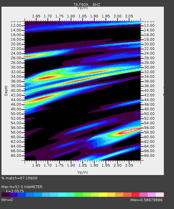
| Estimated Moho Depth: |
57.0 km |
| Estimated Crust Vp/Vs: |
2.06 |
| Assumed Crust Vp: |
6.419 km/s |
| Estimated Crust Vs: |
3.12 km/s |
| Estimated Crust Poisson's Ratio: |
0.35 |
|
| Radial Match: |
97.19608 % |
| Radial Bump: |
246 |
| Transverse Match: |
89.289566 % |
| Transverse Bump: |
400 |
| SOD ConfigId: |
626651 |
| Insert Time: |
2014-04-18 20:35:45.588 +0000 |
| GWidth: |
2.5 |
| Max Bumps: |
400 |
| Tol: |
0.001 |
|
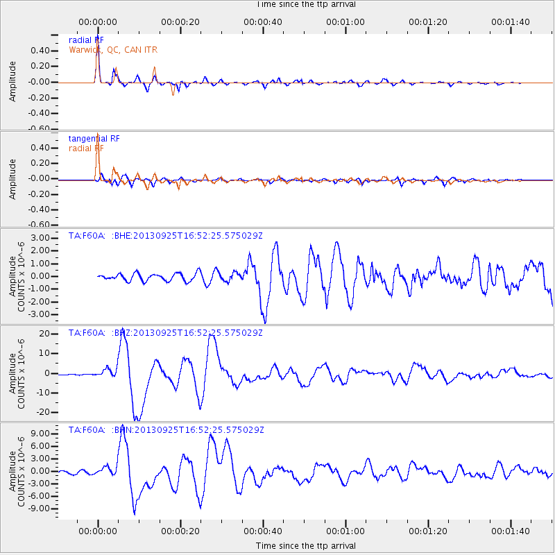
Signal To Noise
| Channel | StoN | STA | LTA |
| TA:F60A: :BHZ:20130925T16:52:25.575029Z | 8.887603 | 2.4218957E-6 | 2.725027E-7 |
| TA:F60A: :BHN:20130925T16:52:25.575029Z | 3.985846 | 1.1936916E-6 | 2.9948262E-7 |
| TA:F60A: :BHE:20130925T16:52:25.575029Z | 1.1373681 | 3.2878336E-7 | 2.8907385E-7 |
| Arrivals |
| Ps | 9.8 SECOND |
| PpPs | 26 SECOND |
| PsPs/PpSs | 36 SECOND |


