You are here: Home > Network List > TA - USArray Transportable Network (new EarthScope stations) Stations List
> Station F61A St Evariste, QC, CAN > Earthquake Result Viewer
F61A St Evariste, QC, CAN - Earthquake Result Viewer

| Earthquake location: |
Near Coast Of Peru |
| Earthquake latitude/longitude: |
-15.8/-74.5 |
| Earthquake time(UTC): |
2013/09/25 (268) 16:42:43 GMT |
| Earthquake Depth: |
40 km |
| Earthquake Magnitude: |
7.1 MWW, 6.8 MI, 7.0 MWB, 7.0 MWC, 7.1 MWW, 7.1 MWC |
| Earthquake Catalog/Contributor: |
NEIC PDE/NEIC COMCAT |
|
| Network: |
TA USArray Transportable Network (new EarthScope stations) |
| Station: |
F61A St Evariste, QC, CAN |
| Lat/Lon: |
45.97 N/70.99 W |
| Elevation: |
350 m |
|
| Distance: |
61.6 deg |
| Az: |
2.789 deg |
| Baz: |
183.851 deg |
| Ray Param: |
0.060694356 |
| Estimated Moho Depth: |
24.75 km |
| Estimated Crust Vp/Vs: |
1.76 |
| Assumed Crust Vp: |
6.419 km/s |
| Estimated Crust Vs: |
3.647 km/s |
| Estimated Crust Poisson's Ratio: |
0.26 |
|
| Radial Match: |
96.250885 % |
| Radial Bump: |
365 |
| Transverse Match: |
85.28501 % |
| Transverse Bump: |
400 |
| SOD ConfigId: |
626651 |
| Insert Time: |
2014-04-18 20:35:46.438 +0000 |
| GWidth: |
2.5 |
| Max Bumps: |
400 |
| Tol: |
0.001 |
|
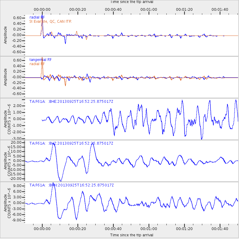
Signal To Noise
| Channel | StoN | STA | LTA |
| TA:F61A: :BHZ:20130925T16:52:25.875017Z | 6.2060275 | 1.9349727E-6 | 3.1178928E-7 |
| TA:F61A: :BHN:20130925T16:52:25.875017Z | 3.692676 | 9.734182E-7 | 2.636078E-7 |
| TA:F61A: :BHE:20130925T16:52:25.875017Z | 1.8277534 | 5.411645E-7 | 2.960818E-7 |
| Arrivals |
| Ps | 3.1 SECOND |
| PpPs | 10 SECOND |
| PsPs/PpSs | 13 SECOND |


