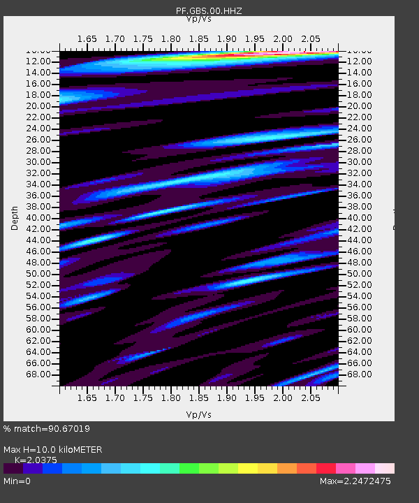
GBS Grandes pentes coulee 1943 bas - Earthquake Result Viewer
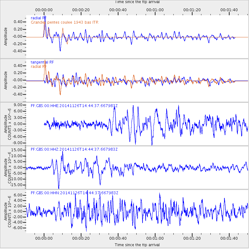
Earthquake location: Northern Molucca Sea
Earthquake latitude/longitude: 1.9/126.5
Earthquake time(UTC): 2014/11/26 (330) 14:33:43 GMT
Earthquake Depth: 39 km
Earthquake Magnitude: 6.8 MWW, 6.8 MWC, 6.8 MWB, 7.0 MI
Earthquake Catalog/Contributor: NEIC PDE/NEIC COMCAT
Network: PF Volcanologic Network of Piton de Fournaise-OVPF
Station: GBS Grandes pentes coulee 1943 bas
Lat/Lon: 21.27 S/55.78 E
Elevation: 471 m
Distance: 72.8 deg
Az: 247.166 deg
Baz: 80.971 deg
Ray Param: 0.05334255
Estimated Moho Depth: 10.0 km
Estimated Crust Vp/Vs: 2.04
Assumed Crust Vp: 4.73 km/s
Estimated Crust Vs: 2.321 km/s
Estimated Crust Poisson's Ratio: 0.34
Radial Match: 90.67019 %
Radial Bump: 400
Transverse Match: 78.840546 %
Transverse Bump: 400
SOD ConfigId: 3390531
Insert Time: 2019-04-15 04:59:27.777 +0000
GWidth: 2.5
Max Bumps: 400
Tol: 0.001

Signal To Noise

ChannelStoNSTALTA
PF:GBS:00:HHZ:20141126T14:44:37.667983Z4.0336652.3536613E-65.835044E-7
PF:GBS:00:HHN:20141126T14:44:37.667983Z0.64822686.3125E-79.738104E-7
PF:GBS:00:HHE:20141126T14:44:37.667983Z0.977614349.283474E-79.4960495E-7
Arrivals
Ps2.2 SECOND
PpPs6.3 SECOND
PsPs/PpSs8.5 SECOND