You are here: Home > Network List > TA - USArray Transportable Network (new EarthScope stations) Stations List
> Station G58A Ormstown, QC, CAN > Earthquake Result Viewer
G58A Ormstown, QC, CAN - Earthquake Result Viewer
| Earthquake location: |
Near Coast Of Peru |
| Earthquake latitude/longitude: |
-15.8/-74.5 |
| Earthquake time(UTC): |
2013/09/25 (268) 16:42:43 GMT |
| Earthquake Depth: |
40 km |
| Earthquake Magnitude: |
7.1 MWW, 6.8 MI, 7.0 MWB, 7.0 MWC, 7.1 MWW, 7.1 MWC |
| Earthquake Catalog/Contributor: |
NEIC PDE/NEIC COMCAT |
|
| Network: |
TA USArray Transportable Network (new EarthScope stations) |
| Station: |
G58A Ormstown, QC, CAN |
| Lat/Lon: |
45.15 N/74.05 W |
| Elevation: |
53 m |
|
| Distance: |
60.7 deg |
| Az: |
0.371 deg |
| Baz: |
180.505 deg |
| Ray Param: |
0.061283 |
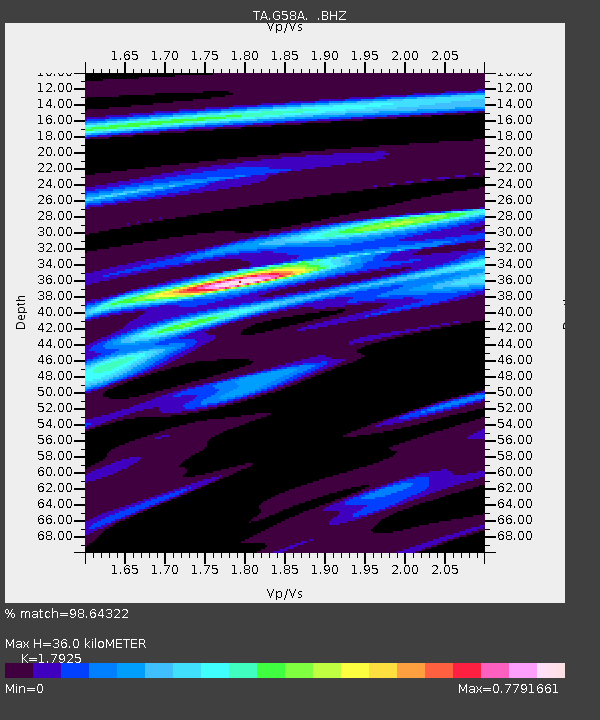
| Estimated Moho Depth: |
36.0 km |
| Estimated Crust Vp/Vs: |
1.79 |
| Assumed Crust Vp: |
6.419 km/s |
| Estimated Crust Vs: |
3.581 km/s |
| Estimated Crust Poisson's Ratio: |
0.27 |
|
| Radial Match: |
98.64322 % |
| Radial Bump: |
189 |
| Transverse Match: |
91.275826 % |
| Transverse Bump: |
396 |
| SOD ConfigId: |
626651 |
| Insert Time: |
2014-04-18 20:36:33.907 +0000 |
| GWidth: |
2.5 |
| Max Bumps: |
400 |
| Tol: |
0.001 |
|
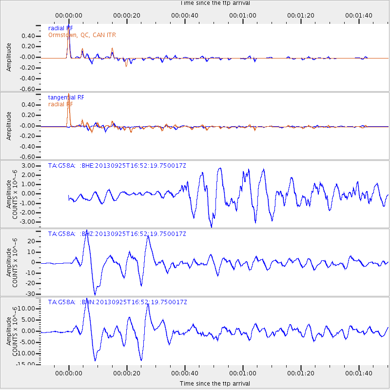
Signal To Noise
| Channel | StoN | STA | LTA |
| TA:G58A: :BHZ:20130925T16:52:19.750017Z | 8.116118 | 2.4790245E-6 | 3.054446E-7 |
| TA:G58A: :BHN:20130925T16:52:19.750017Z | 7.5932384 | 1.3183462E-6 | 1.7362107E-7 |
| TA:G58A: :BHE:20130925T16:52:19.750017Z | 1.0043304 | 3.6561678E-7 | 3.6404035E-7 |
| Arrivals |
| Ps | 4.7 SECOND |
| PpPs | 15 SECOND |
| PsPs/PpSs | 20 SECOND |


